Summary
 The Peri-urban Deer Control Plan 2021–26 (the Plan) is Victoria’s plan to reduce the impact of deer across the peri-urban region east and north of Melbourne. The aim of the Plan is to have a consistent framework to guide investment and collaborative on-ground action for the greatest net benefit across multiple values and land tenure.
It is the first of 3 region-specific plans developed to address the state’s deer control response under the Victorian Deer Control Strategy (VDCS).
Wild deer cause a wide range of environmental, economic, and social impacts in Victoria. The most significant impacts identified in the peri-urban area are the values of biodiversity, water quality, public safety, agricultural assets and Aboriginal cultural heritage.
Modelling indicates that if we do not act, deer will spread across Victoria. We are already seeing evidence of this in the peri-urban plan area.
The Plan was prepared in consultation with a regional partnership group made up of local partners and stakeholders involved and interested in managing deer impacts including land managers, local government, conservation, industry, community groups and Traditional Owners.
The Plan will help partnership group members and the community develop local approaches to deer control. Individual landholders can also use the Plan to guide cost-effective deer control and to contribute to monitoring where appropriate.
This plan is intended to be used as a tool to prioritise and guide deer control in Peri-urban areas to the east of Melbourne. The Plan outlines the values being impacted by deer, current control efforts and prioritisation of these efforts to improve deer control in peri-urban areas. The Plan should be read with the following supporting documents:
The objectives of Victoria’s Deer Control Framework are to:
- prevent new deer populations from establishing in Victoria (prevention)
- remove isolated populations of deer (eradication)
- limit the spread of deer beyond their current geographic range (containment)
- protect and reduce the impacts of deer on priority values (asset protection).
The Victorian Government’s approach to biosecurity is based on the return-on-investment principle, whereby the greatest return on investment is achieved through activities that prevent the entry and establishment of a species.
Where possible, prevention is the most cost-effective means of dealing with invasive species. The benefit-cost ratio decreases as a species become more widespread. In areas where deer are established, containing the population and protecting assets may be the only options.
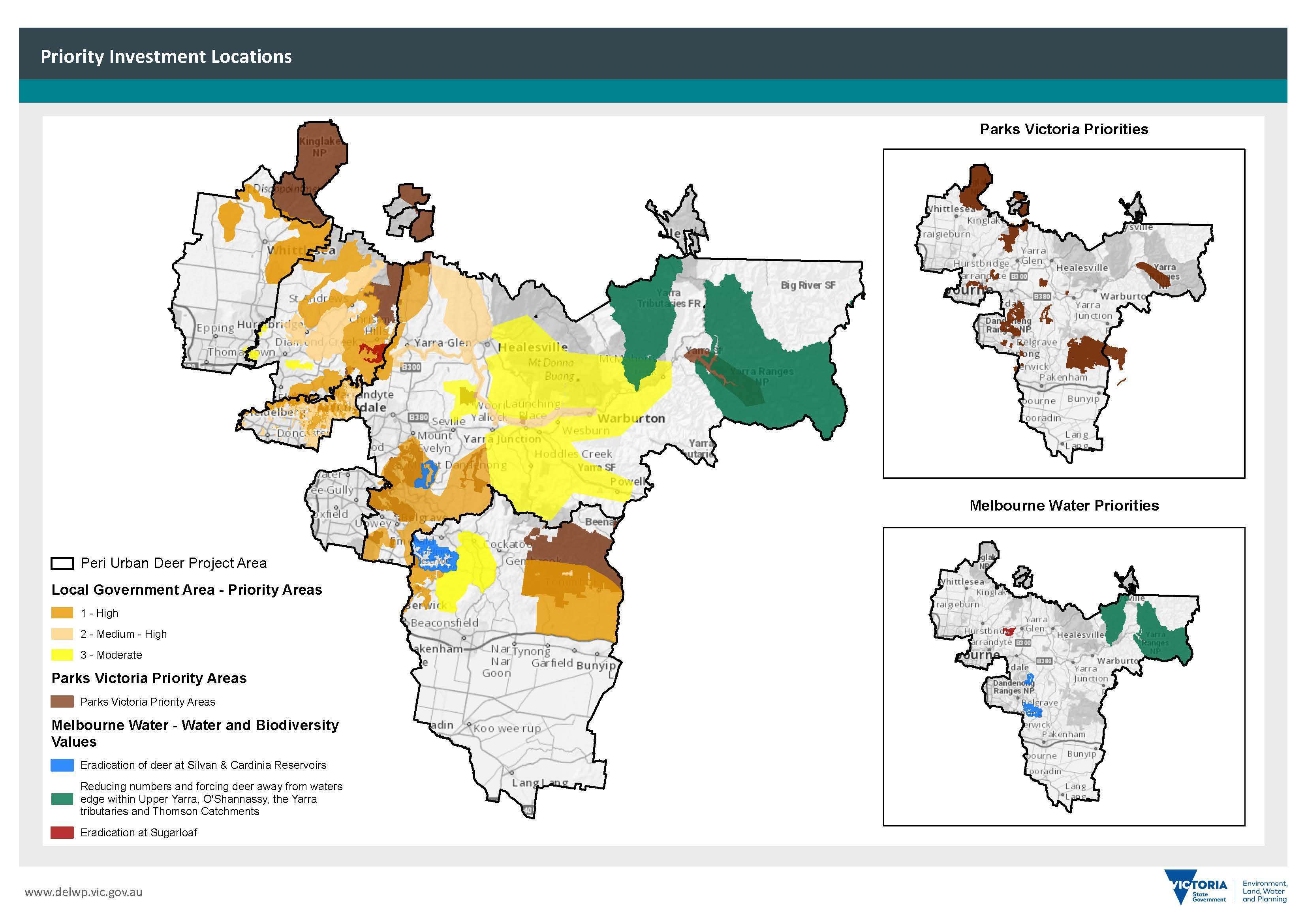
The Plan identifies priority areas for government and community investment in deer control, as shown in the map below.
The priority investment locations map is designed to be used with the prioritisation matrix to assess whether investing in deer control is worthwhile at specific locations.
The Department of Environment, Land, Water and Planning (DELWP), land managers and project managers can use these tools to identify cost-effective and strategic locations to carry out deer control, surveillance, and other local management measures.
The prioritisation matrix helps narrow down the best sites for deer control both within mapped priority investment locations and at non-mapped sites if sufficient impacts are observed.
This Plan identifies actions to be rolled out over the next five years to improve deer control in the peri-urban area.
The peri-urban deer control plan on a page provides a snapshot of goals, actions and expected outcomes to be delivered under this Plan.
We will evaluate the Plan against the key performance indicators established for each action. In addition to the five-yearly review, we will update the Plan as new information becomes available.
This will be particularly important during the first year of the Plan.
Vision
Deer are no longer significantly impacting priority environmental, agricultural, and Aboriginal cultural heritage values and public safety in Victoria.
To be achieved by working together to minimise the impact of deer across the Plan area.
Goals and Actions
1. The impacts of deer on key environmental, agricultural and Aboriginal cultural heritage values and public safety are reduced
- Undertake deer control and management activities in priority locations
- Develop collision register for deer-vehicle accidents
- Target high priority riparian waterways and water supply network sites
- Work with partnership members to support the use of deer carcasses
- Control deer before planting, revegetation or establishment of plantations and as ongoing activity
- Map deer fencing in the periurban area to support deer control planning
- Undertake a yearly review of the Regional Plan
2. Deer control is more effective through partnerships and community collaboration
- Build capacity to protect Aboriginal cultural heritage through Traditional Owners
- Review role of government in supporting standard accreditation process for shooters
- Hold yearly masterclass for deer control
- Increase community understanding of deer impacts and control options through collaborative programs
- Install demonstration deer fences and shooting platforms
3. Awareness, understanding and capacity to control deer is increased
- Develop and share deer density monitoring methodology for the peri-urban landscape
- Quantify impacts of deer on agricultural enterprises in peri-urban areas
- Develop and promote a Ground Shooting Standard Operating Procedure (SOP) for deer control in peri-urban areas
- Contribute to research priorities by identifying knowledge gaps
- Enhance citizen sciences for deer program
- Support mitigation measures including signs, deterrent devices, and media to reduce impacts of deer and increase community awareness of deer and control options
Outcomes
- Protect high-value biodiversity
- Protect agricultural enterprises impacted by deer
- Protect areas of cultural sensitivity
- Increase public safety by reducing deer collisions
- Protect water quality
Introduction
Deer are present in large areas of Victoria. Without management action, modelling indicates that deer could spread across the entire state.
Wild deer in Victoria and the peri-urban area affect biodiversity, water quality, public safety, agricultural assets and Aboriginal cultural heritage.
The Peri-urban Deer Control Plan 2021–26 (the Plan) is the first of three region-specific plans developed to address the state’s deer control response. It covers the areas predominantly east of Melbourne where deer populations have become problematic.
The Plan outlines management actions to improve deer control and assesses the most cost-effective and strategic locations to undertake deer control.
A key objective of this Plan is to guide investment and collaborative on-ground action for the greatest net benefit across multiple values and land tenure.
We will give highest priority to actions that provide the greatest net benefit to biodiversity.
The Plan will build on existing control efforts but with more strategic coordination of future control work. Both government and community will need to work together to achieve the vision for this Plan.
This five-year Plan is adaptive to respond to new information and will enable continuous improvement. We will update deer control locations as further information becomes available.
Regional plans outline:
- the values significantly affected by deer and the values at future risk, based on current and projected deer distribution
- current deer control efforts
- the most cost-effective and strategic locations to undertake deer control, surveillance, or other management activities in line with the biosecurity approach described later in this Plan to address impacts and risks and provide the greatest net benefit, and
- monitoring and evaluation plans.
This Plan also includes a prioritisation matrix that is designed to guide investment in deer control over the life of the Plan.
Land managers and owners can use the matrix to identify the most strategic locations for deer control based on the data, research and mapping underpinning this Plan.
In 2020, the Department of Environment, Land, Water and Planning (DELWP) released the Victorian Deer Control Strategy (VDCS) – a new approach to deer management to reduce the impact deer are having across Victoria.
The strategy is underpinned by a Deer Control Framework to provide a coordinated, strategic, and adaptive approach to managing the impacts of deer (Figure 1).
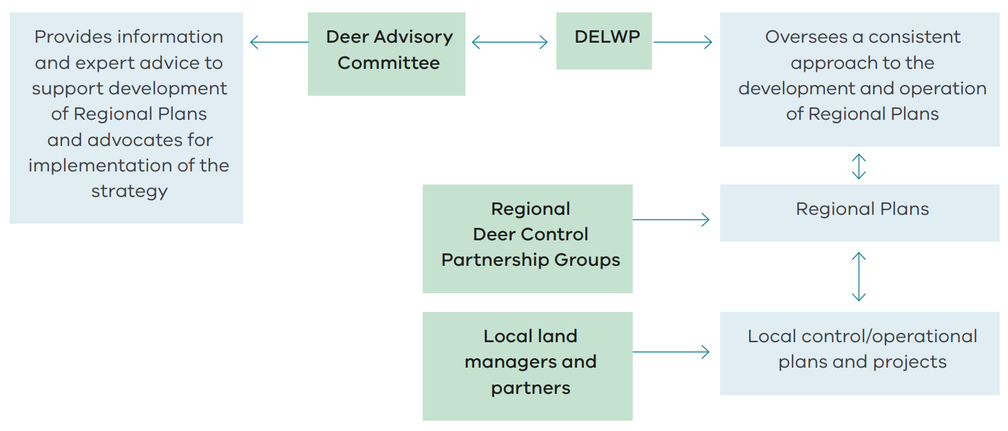
Figure 1: Deer Control Framework under the Victorian Deer Control Strategy
The VDCS includes regional plans as the mechanism to identify priority locations for deer control work. The strategy allows the development of regional plans by Regional Deer Control Partnership Groups established by the Victorian Government (see Partnership Group below).
The vision of the VDCS is adopted in this Plan, with minor amendments as shown in Figure 2. It also aligns with the same guiding principles as the VDCS (see Appendix 1: Guiding principles).
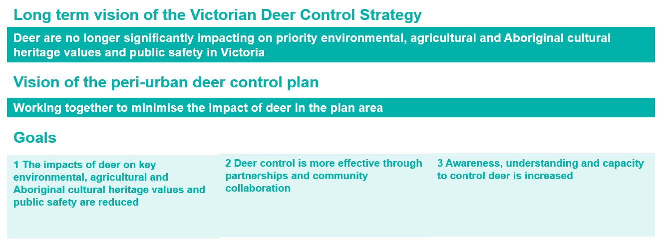
Figure 2: Vision and goals of the Victorian Deer Control Strategy
The Plan covers public and private land in Melbourne’s outer east, north, north-east and south-east (Figure 3).
This area includes diverse landscapes, multiple land tenures and a mix of peri-urban.
Urbanised areas include Doncaster and Knox, semi-rural towns such as Hurstbridge and Gembrook, and rural locations such as Tonimbuk and Powelltown.
The area also contains large expanses of native vegetation managed by agencies such as Melbourne Water, Parks Victoria and DELWP.
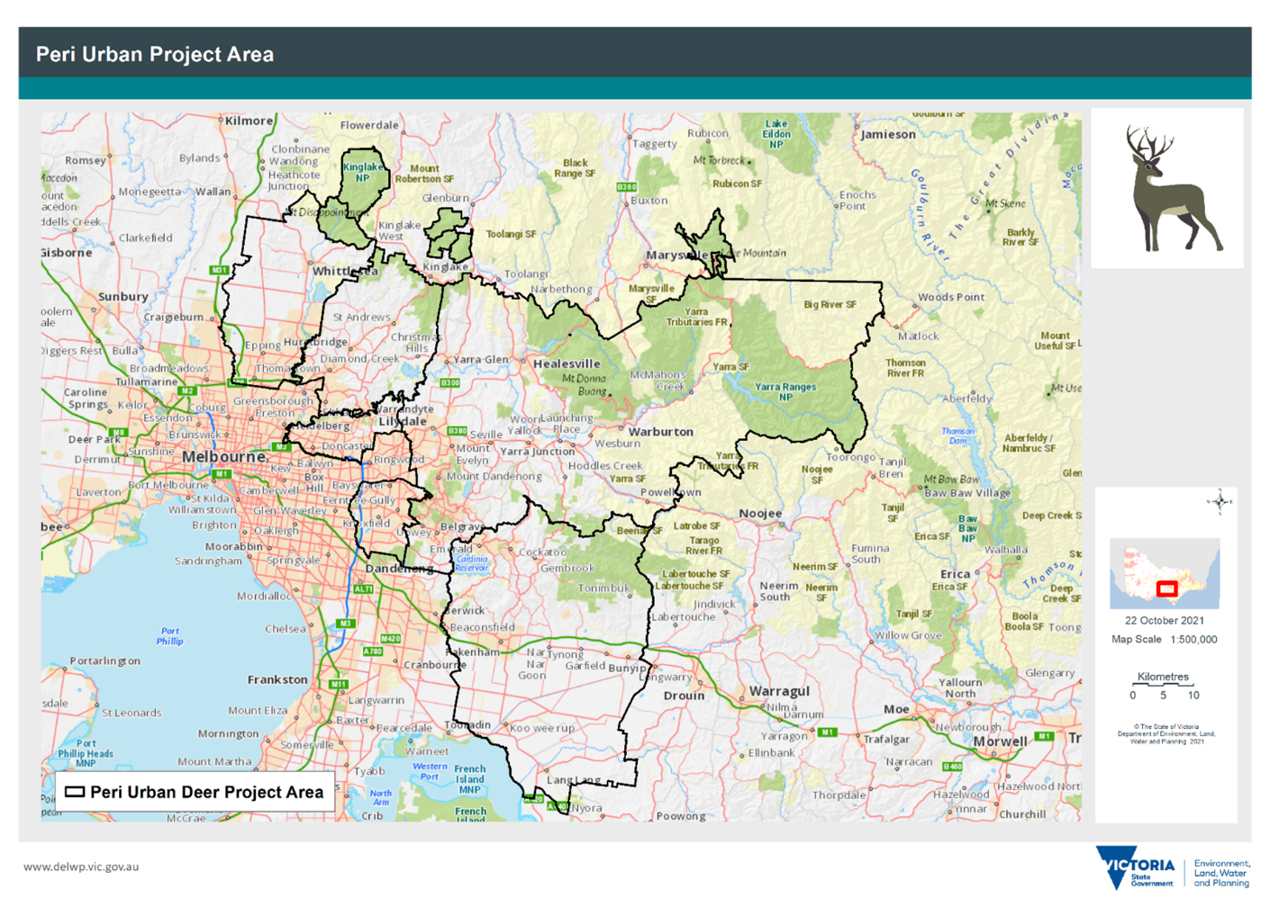
Figure 3: Peri-urban plan area
Key national, state parks and forests in this area include:
- Kinglake National Park
- Plenty Gorge Parklands
- Yarra Ranges National Park
- Bunyip State Park
- Kurth Kiln Regional Park
- Warramate Hills Nature Conservation Reserve
- Warrandyte State Park
- Yellingbo Nature Conservation Reserve
- Hoddles Creek Nature Bushland Reserve
- Beenak Bushland Reserve
- Wright Forest Bushland Reserve
- Yarra State Forest
- Beenak State Forest
- Big River State Forest, and
- Mt Disappointment State Forest.
DELWP formed a partnership group (the peri-urban partnership group) including local partners and stakeholders involved and interested in managing deer impacts, including land managers, local government, conservation, industry and community groups.
Partnership group members include:
- Agribusiness Yarra Valley
- Cardinia Deer Management Coalition
- Cardinia Shire Council
- City of Whittlesea Council
- DELWP
- Green Wedge Coalition
- Jumping Creek Landcare Group
- Knox City Council
- La Trobe University
- Manningham City Council
- Melbourne University
- Melbourne Water
- Nillumbik Shire Council
- Parks Victoria
- Port Phillip Catchment Management Authority
- VicRoads, and
- Yarra Ranges Shire Council.
These contributors will work towards achieving the Plan vision through the actions listed later in Prioritising locations for deer control.
Assessment of Country and identifying cultural values that may be affected by deer is an important part of the development and implementation of this Plan.
Traditional Owners were engaged separately as key partners and provided input into the Plan including areas of cultural significance.
Three Traditional Owner groups are recognised in the peri-urban plan area:
- Wurundjeri
- Bunurong
- Taungurung.
This Plan is publicly available to guide cost-effective investment into control and management activities to reduce the impacts of deer. The Victorian Government is providing investment through the Victorian Deer Control Program and will involve direct commissioning of priority projects and/or open grant rounds seeking proposals that align with this Plan.
It is anticipated that based on Victorian Government investment alone, the Victorian Deer Control Program will contribute 150,000 ha annually to the Biodiversity 2037 contributing targets. DELWP will report on the location and extent of deer control across all the plans as they as they are implemented
Noting that parts of the Plan will be updated regularly, the investment will be guided by the information and data underpinning the latest version of this Plan.
Landholders and land managers can use the prioritisation matrix to assess sites for consideration using a consistent set of values.
Site-specific information should also be combined with broader landscape information. This information, together with options for control, will help determine the best approach to deer control, which is likely best achieved through collaboration with neighbouring landholders and land managers.
Deer in Victoria
Deer are among the world’s most successful invasive mammals and can have substantial harmful impacts on natural and agricultural ecosystems.
Six species have established wild populations in Australia, and the distributions and abundances of some species are increasing (Davis et al, 2015).
Deer are scattered across Victoria, with Sambar dominating the eastern half of the state as shown in Figure 4.
Deer are found mostly in more heavily vegetated areas, and they are often found on public land such as national and state parks and forests.
Deer are seen increasingly in suburban Melbourne and a range of rural towns and cities.
Deer populations in urban fringe areas such as the Dandenong Ranges and Yarra Valley have been reported for the last 10 years, but they are now present in many urban places. This will continue as deer become more widely distributed.
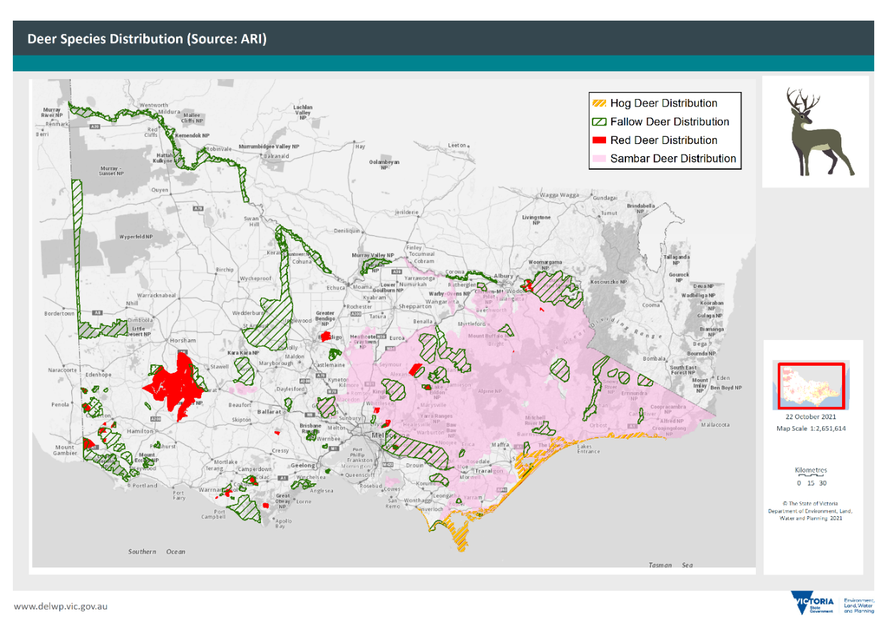
Figure 4: Deer breeding distribution in Victoria based on data modelling using the Victorian Biodiversity Atlas, the Atlas of Living Australia, and FeralScan (December 2020)
Green wedge areas in peri-urban local government areas (LGAs) around Melbourne have become the perfect habitat for many deer species (Figure 5).
Much of the remnant bushland in these areas are found on private land, sometimes adjoining larger conservation sites.
There are many open grazing areas, farm dams and vegetated waterways, and a ready supply of feed in pastures, home gardens, vineyards, and orchards.
The increasing presence of deer on private land has led to a rise in complaints from landholders. Landholders are often unable to manage deer themselves, so public land managers have the chance to work across land tenures using professional controllers to manage rising deer numbers.
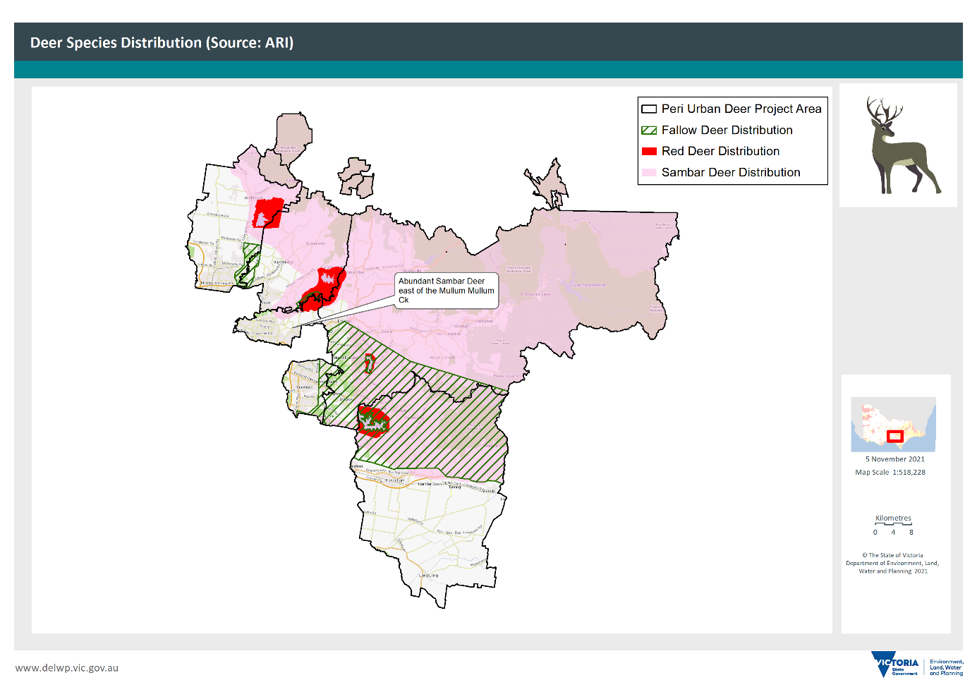
Figure 5: Deer distribution in the peri-urban plan area
The peri-urban plan area includes large tracts of public land that may allow deer to spread into urban areas from forests. It is vital to contain deer in these areas because deer control is not practical in highly urban areas.
Deer tend to migrate via waterways, with the Yarra River forming a main corridor of movement. It is important to identify suitable and strategic control locations for containment lines and choke points to prevent further movement beyond the peri-urban LGAs.
Hog, Red, Sambar, Fallow, Rusa, Chital, Sika and Wapiti deer are protected wildlife under the Victorian Wildlife Act 1975.
Hog, Red, Sambar, Fallow, Rusa and Chital deer are also defined as game, which means they can be hunted by licensed game hunters.
All species except Hog deer are unprotected on private property and can be controlled by the property owner where they are causing damage and without a Game Licence or permit under the Wildlife Act.
Deer control on public land needs authorisation under the Wildlife Act. One of the actions listed in the VDCS is to remove this requirement.
A range of legislation needs to be considered when controlling deer, including:
- Wildlife Act 1975 Section 7A Declaration of Certain Wildlife as Unprotected Wildlife on Private Property, March 2018
- Wildlife Act 1975
- Catchment and Land Protection Act 1994
- Flora and Fauna Guarantee Act 1988 (FFG)
- Meat Industry Act 1993
- Prevention of Cruelty to Animals Act 1986
- Firearms Act 1996
- National Parks Act 1975
- Conservation, Forests and Lands Act 1975
- Parks Victoria Act 2018
- Environment Protection and Biodiversity Conservation Act 1999 (EPBC)
Deer, particularly Sambar, are found across much of eastern Victoria.
Figure 6 shows the deer threat and impact sites recorded by the Eastern Region Pest Animal Network and hotspots of deer sightings recorded through citizen science activities.
Deer activity is concentrated in the fringe areas between bushland reserves and rural farmland, and along waterways and vegetated gullies.
These corridors act as movement pathways through the landscape and may be used as effective locations to track deer from one patch of habitat to another.
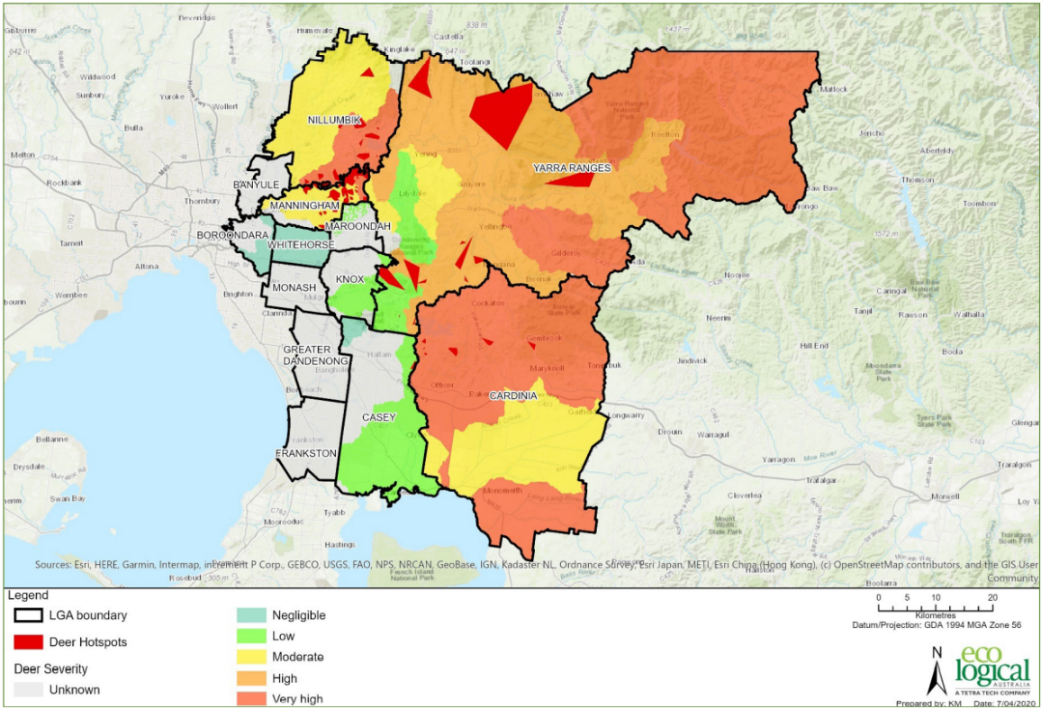
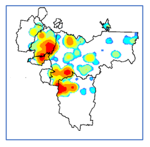
Figure 6: Eastern Region Pest Animal Network (ERPAN) map of deer threats (2020) (above) and hotspots (below) based on recent deer sighting records
Values being impacted by deer
Wild deer cause a wide range of environmental, economic, and social impacts, although limited work has been done to quantify these impacts.
The most significant risks in the peri-urban plan area are impacts to the values of biodiversity, water quality, public safety, agricultural assets and Aboriginal cultural heritage.
Evidence in Australia, including from the eastern Melbourne region, shows that wild deer can damage the natural environment with noticeable impacts in the fragmented landscape typical of the peri-urban environment.
Deer reduce and destroy native vegetation and compete with native wildlife for food sources. As deer density increases in an area, the abundance and diversity of plant species is reduced (Bennet 2008).
Deer damage includes browsing native vegetation, damaging trees, spreading weed seeds and fouling water.
Specific damage includes defoliation (young and/or old leaves), removing shoots, stripping bark, and destroying or eating plant reproductive material, which could reduce plant population viability (Keith and Pellow 2005). Sambar deer dietary studies have identified up to 105 species being consumed (Forsythe et al 2011).
Prolonged grazing appears to have caused widespread prevention of plant regeneration, with the potential for loss of entire plant communities in some areas (Peel et al. 2005) (see Hampton and Davis 2021 for impacts summary in Victoria).
In the peri-urban plan area, specific biodiversity impacts include:
- Breeding of the critically endangered Helmeted Honeyeaters in Yellingbo Nature Conservation Reserve is threatened by deer browsing, including in FFG-listed ‘Sedge-rich Eucalyptus camphora Swamp’, severely damaging and suppressing recruitment and reducing the dense vegetation cover needed.
- In Yarra Ranges National Park, preferential browsing of Hazel Pomaderris (Pomaderris aspera), Prickly Tea-tree (Leptospermum continentale) and Prickly Bush-pea (Pultenaea juniperina) has reduced biomass of forest understories in open herb-rich areas which attract higher densities of Sambar (Bennett 2008).
- Ringbarking by Sambar deer antler rubbing threatens the last remaining population of the EPBC-listed Shiny Nematolepis (Nematolepis wilsonii) in the O’Shannassy River catchment near Marysville, with trampling likely to inhibit recruitment. (Murphy et al 2006; Bennett 2008).
Other impacts reported by field staff, but not subject to scientific studies include:
- trampling of wet depressions in the Sugarloaf Reservoir where endangered Southern Toadlets lay their eggs, which is likely to impact breeding successes, and
- deer browsing of indigenous daisies, wattles, and peas, is considered a threat to the Rosella Spider-orchid in Nillumbik as the orchid’s key pollinator species, a bee of the Leioproctus genus, relies on these plants.
In the peri-urban area, water supplied to consumers from Melbourne Water and Yarra Valley Water is recognised for its high quality and is highly valued by the community.
Figure 7 shows the protected water supply catchments that Melbourne relies on for a safe drinking water supply. For a large city like Melbourne, the high quality of water supplied by these catchments is rare.
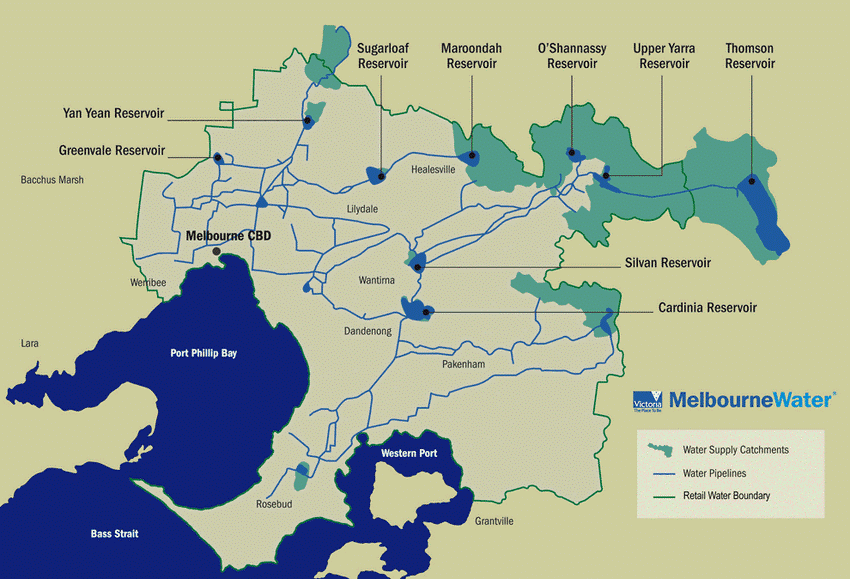
Figure 7: Melbourne Water supply catchments and reservoirs
Deer are linked to the spread of some of diseases and parasites. A range of these are described in the VDCS.
While other animals are known carriers of the parasite, Cryptosporidium spp., deer carry an increased risk as they appear more than other host species near these protected catchments.
This parasite can contaminate reservoirs and cause infection in humans (cryptosporidiosis). The protected catchment areas do not have drinking water treatment systems designed to manage Cryptosporidium. Failure to control deer could force additional water treatment at significant cost.
Protecting these reservoirs and catchments from contamination is critical to maintaining a safe and inexpensive drinking water supply without the need for water treatment costs used in most comparable cities.
Additional water treatment measures may increase costs. In the Yarra Valley, 70% of water is collected from protected catchments and 30% from unprotected catchments areas including Yan Yean and Sugarloaf Reservoirs.
Given the connectivity of the land surrounding both open and closed catchments and the absence of deer exclusion fencing, re-invasion of deer into these areas is likely unless ongoing control programs are implemented.
Targeted control programs in closed (fenced) catchments could eradicate deer at high priority locations.
Scheduled deer control by Melbourne Water is already contributing to reduced deer numbers at some locations.
Figure 8 shows Melbourne Water key investment areas in deer control and research for vegetated waterways and reservoirs.
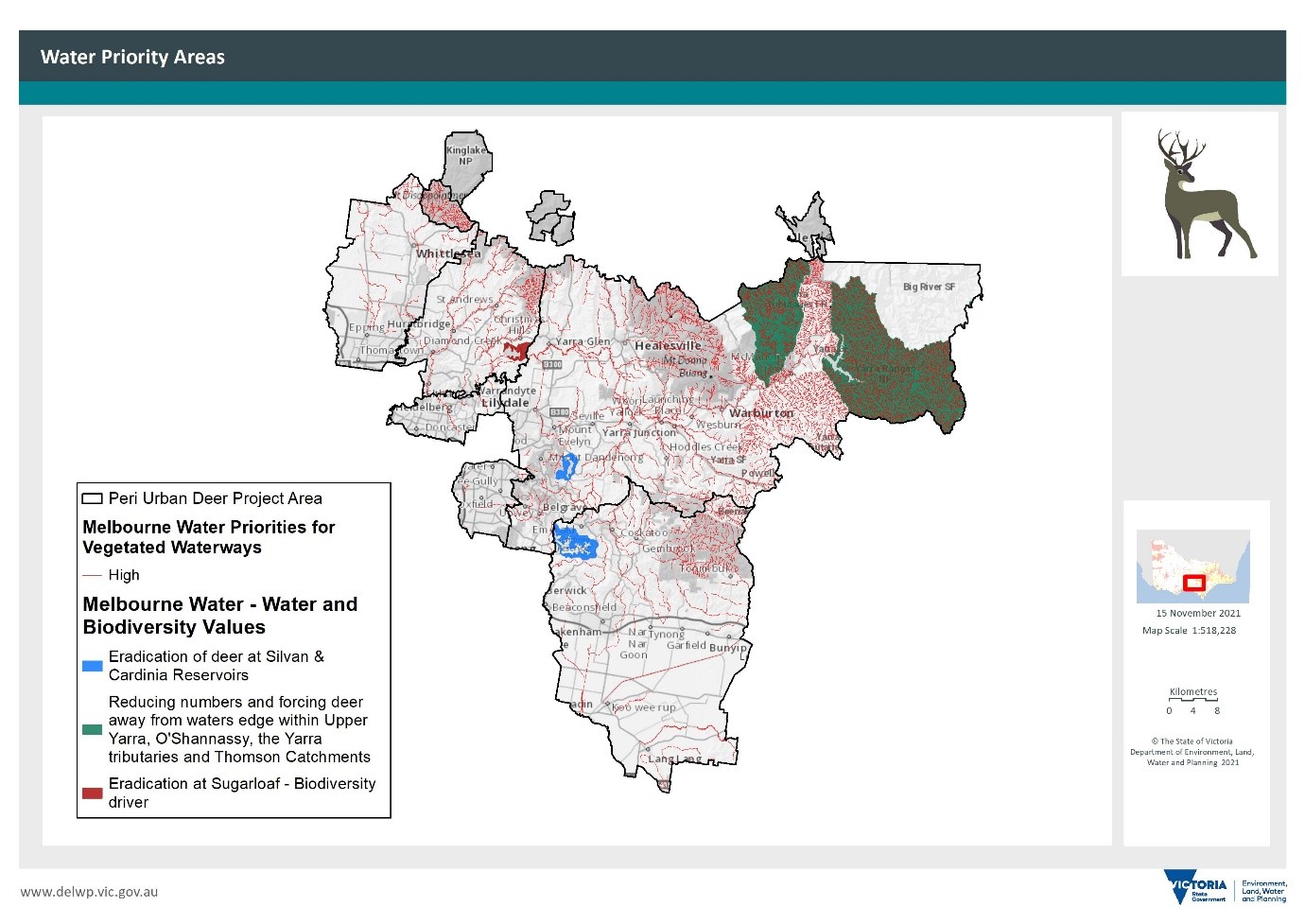
Figure 8: Priority reservoirs map and areas of Melbourne Water deer management
As deer distribution and abundance increase, deer sightings and reports of the public safety risk are becoming more common, particularly in peri-urban areas (Figure 9).
In densely populated areas, deer are a growing public concern, appearing in backyards, schools, and other public places.
Deer may charge or kick people if they feel threatened. Given their size, they can cause significant and even fatal injuries, particularly associated with vehicle collisions.
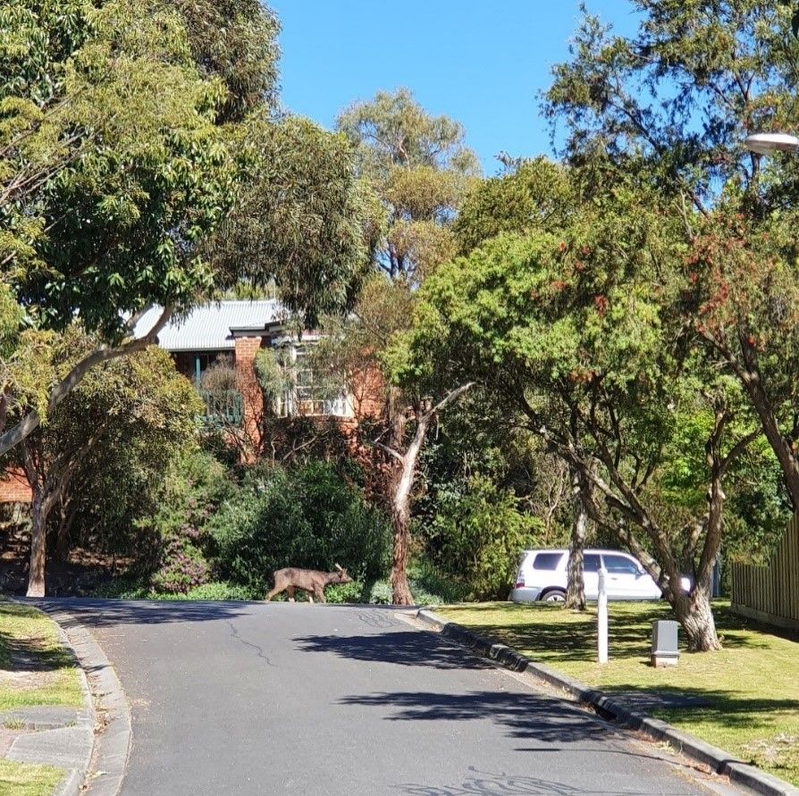
Figure 9: A Sambar deer in Warranwood
Unauthorised hunting and discharge of firearms in urban areas can heighten the risk of injury and distrust of hunters.
The prevalence of deer outside of known existing distribution is likely to increase public safety impacts in the future without interventions such as control programs in adjoining areas.
Many thousands of collisions occur between motor vehicles and native animals, livestock, and deer each year across Australia (Rowden et al. 2008).
Costs from animal damage average $3,000 per incident (Sunrise Exchange News 2007).
Figure 10 shows the outcome of a deer-vehicle collision (DVC).
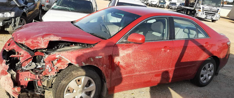
Figure 10: Deer–vehicle collision, regional Victoria
The risk of DVCs is increasing in south-east Australia as populations of deer expand rapidly.
Deer were the fourth most common animal resulting in a vehicle damage claim between 2011 and 2015 (RACV 2015).
DVCs are most common in the early evening as deer emerge to feed (Ramp and Roger 2008).
There are also many unreported ‘near misses’ with deer, with some regular road crossing points identifiable by deer trails formed through deer travelling regularly between feeding and bedding areas.
Road managers are implementing options to increase awareness for road users (Figure 11).
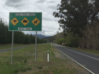
Figure 11: VicRoads roadside signage, Alpine Highway, Bright (Photo: Stefan Kaiser)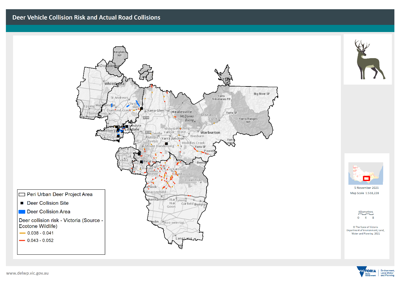
Figure 12: Map of deer-vehicle collision risk and road collisions in the peri-urban plan area (Source: Council records (where available), a study into predicting DVC-risk areas (Davies et al., 2020) and the Wildlife Victoria online tool with historical deer data including DVCs)
Agriculture across the peri-urban plan area is diverse and varies from intensive agriculture to grazing enterprises (Figure 13).
Cattle, sheep, and variable-sized hobby farms are intermixed throughout the area, as well as intensive agricultural enterprises such as vineyards, horticulture, and strawberry farms.
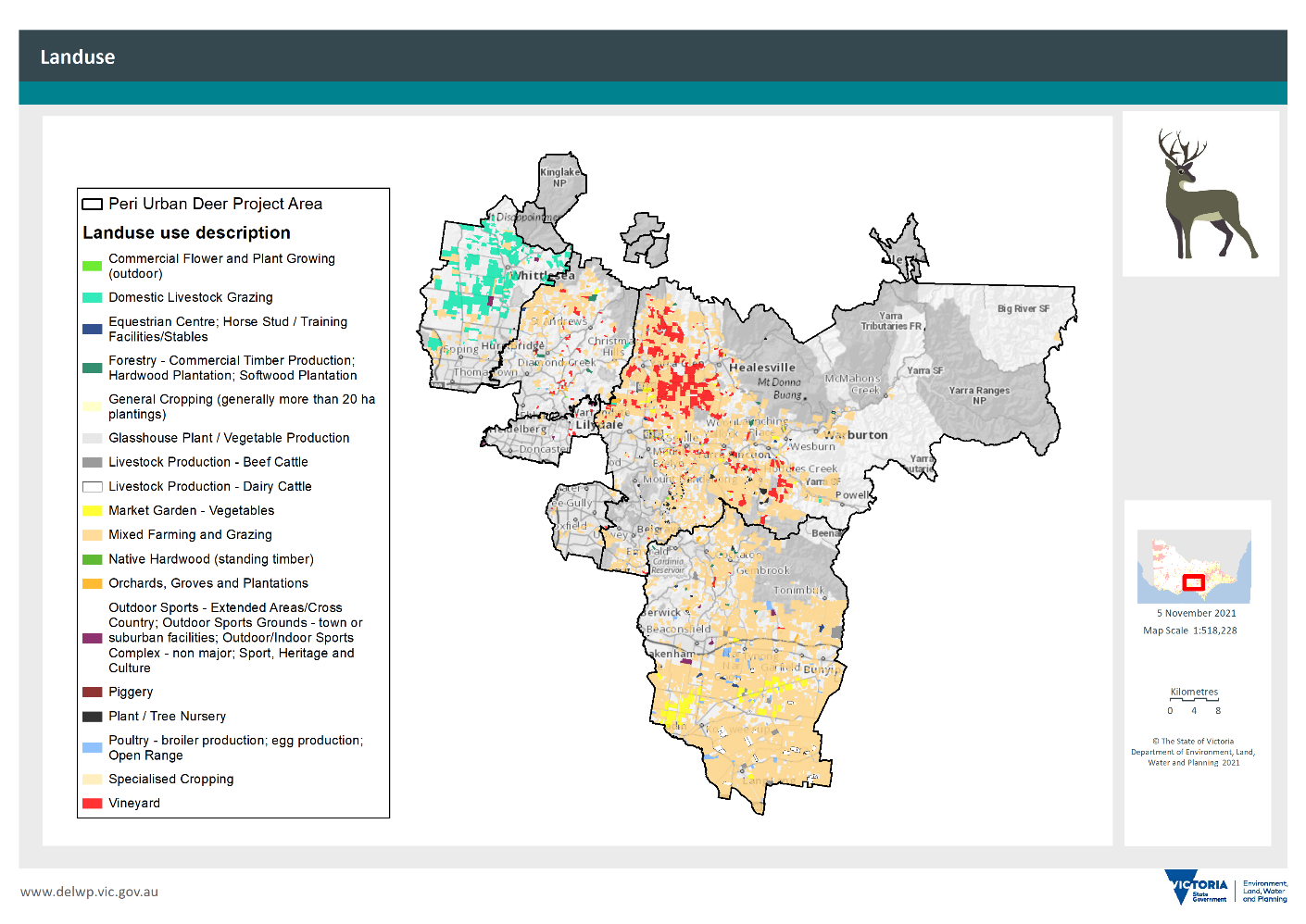
Figure 13: Land use in the peri-urban plan area
This presents a range of unique issues and problems for property owners with deer present in low and high densities.
In areas with a higher density of settlement as seen in the Dandenong Ranges, deer graze gardens.
Deer could affect each type of enterprise, depending on proximity to suitable deer habitat. Agricultural enterprises close to areas that offer cover and grazing are sites of most concern.
The Yarra Valley and Dandenong Ranges are highly valued for their agriculture, horticulture, and viticulture, with an estimated worth of more than $559 million.
They attracted more than 7 million tourists in 2015–16, with a total contribution of $1 billion in direct tourism in the region.
Intensive horticulture such as vegetables, strawberries, orchards, or vineyards can be affected by grazing or physical damage by deer. It is reported that pasture or fodder crops are often affected by deer. Farmers that have crops set aside for grazing see losses when adjoining sites contain deer.
Agricultural and forestry locations occur within the peri-urban plan area. Softwood and hardwood plantations are affected by foliage browsing and mechanical damage.
In some cases, severe losses are incurred from deer browsing, usually, in plantations, less than five years of age as softwood and hardwood plantations are at greater risk in their establishment phase (up to two years old) (Figure 14).
Control actions have been used to reduce the impact of deer in young plantations, including professional shooters.
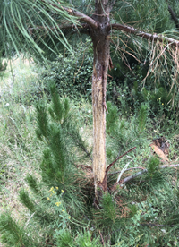
Figure 14: Bark stripping on radiata pine (Photo: Stefan Kaiser)
Grazing by a few deer are less likely to be a problem in pastures, but depending on the agricultural enterprise, even one deer can cause damage.
Some species such as Fallow deer and Red deer are more likely to be present in herds compared to Sambar deer.
Management options vary depending on whether deer densities and impacts need to be eliminated (using fencing) or reduced (using control, deterrents, or changes to management practices).
Landholders can protect their properties from deer browsing using a variety of fencing options. Electric fencing is one example (Figure 15).
In some instances, where deer are known to be nearby, locating fences on known movement corridors might redirect deer and prevent them from accessing new habitat areas.
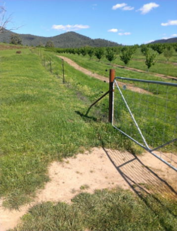
Figure 15: Electric fence designed to keep deer out of an orchard (Photo: Karen Maroney)
Aboriginal cultural heritage sites can be threatened by deer rubbing scar trees and travelling along stream verges because of their hooves and ongoing tracking, grazing, and trampling.
Increasing deer impacts may cause the loss of plant species that are culturally important for medicine, food or that are strongly connected to activities such as revegetation programs.
Deer management and control efforts are not expected to pose any risk to cultural heritage values unless earthworks are carried out to build traps or fences, or to bury animals or offal.
Figure 16 shows the cultural heritage sites in the peri-urban plan area. Since stream verges are often sites of activity, all stream verges are buffered to flag areas of sensitivity.
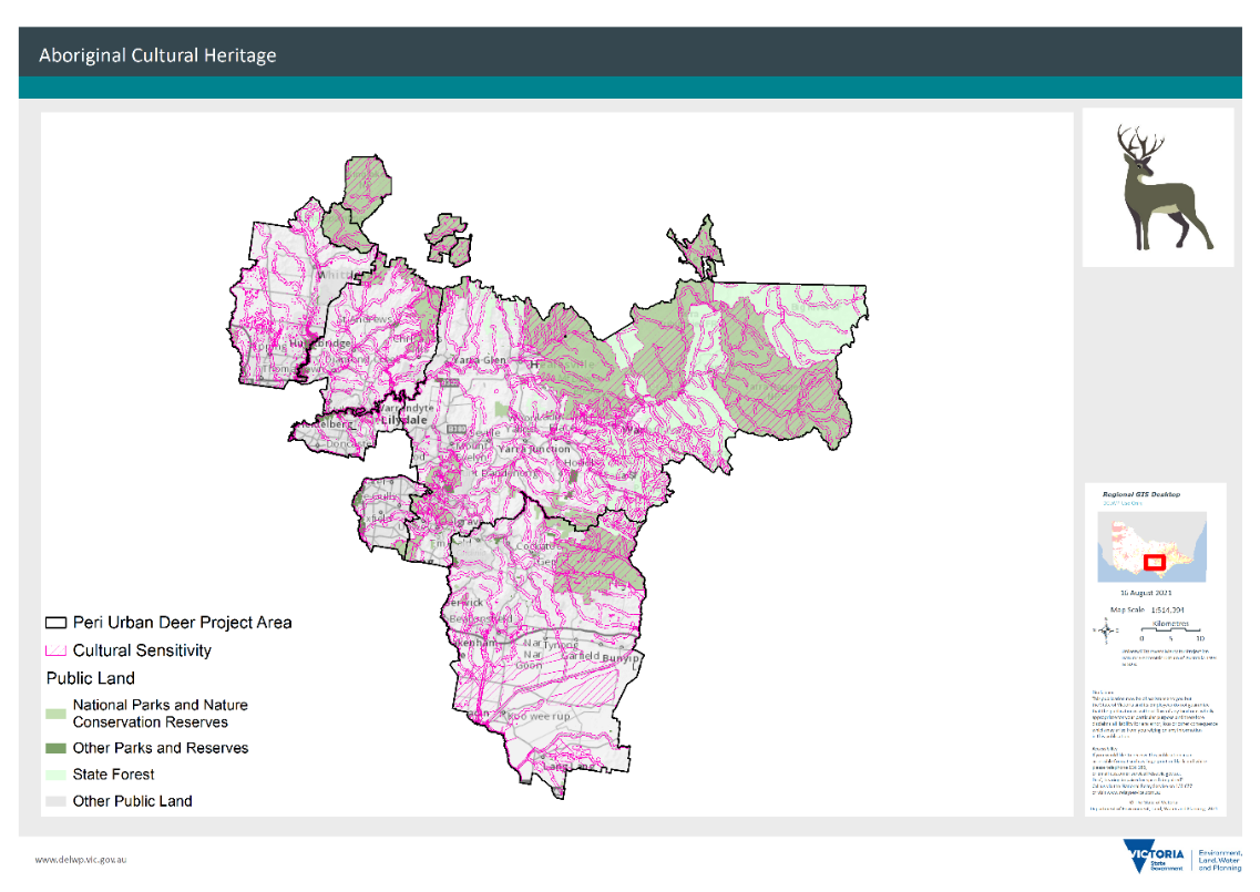
Figure 16: Areas of Aboriginal cultural heritage in the peri-urban plan area
While sensitive sites have been mapped, ongoing monitoring is needed to provide protection. The mapping in this Plan and further conversations with Traditional Owners can provide additional insights to identify areas for future protection.
If working in an area of cultural heritage sensitivity, a cultural heritage management plan must be prepared under the Aboriginal Heritage Act 2006.
Refer to the:
for more information on how to assess whether the land is in an area of cultural heritage sensitivity and how to meet the requirements of the Aboriginal Heritage Act.
Increasing knowledge on deer for the whole community including Traditional Owners will lead to future benefits for values and is one of the aspirations of the Plan.
Training can help to increase knowledge on deer control and lead to greater protection of high-value areas.
Current deer control efforts
Deer control activities occur across the peri-urban area and are usually focused on higher density or impact sites, as part of asset-based protection programs.
These activities are managed by:
- DELWP
- Parks Victoria
- Melbourne Water
- private land managers
- Landcare and community groups.
Parks Victoria, Melbourne Water and local governments also work with community members and contractors to control deer at various sites.
DELWP and Parks Victoria’s deer control programs tend to have a strong focus on protecting biodiversity values on public land, particularly in national parks and reserves.
Melbourne Water’s deer control program is focused on managing risks to drinking water quality, meeting land management obligations, and supporting waterway outcomes. Melbourne Water runs several intensive control programs focused on eradicating and reducing deer around tributaries, catchments, and reservoirs.
Private land managers can treat deer on their own property and, in some cases, have been supported by local government or state funding. Landowners can make decisions about deer control independent of this Plan.
Wherever possible, deer control projects should be integrated with other on-ground controls such as fencing, vegetation protection and revegetation. Integrating with community-driven programs and initiatives like $77 million BushBank that commit to revegetation is desirable as deer can often browse newly planted trees.
On public or private land, control activities should consider the potential temporary shift of animals to any adjoining area and the movement of deer along with feeder areas away from work areas. Control programs must be at a scale that is large enough to ensure deer populations and damage are reduced effectively.
The prioritisation matrix helps guide and support the allocation of additional Victorian Government funding to progress cost-effective deer control.
Figure 17 shows the location of some recent deer control works across the peri-urban area that aligns with distribution areas and are located around key assets for protection (e.g. water reservoirs) and along with fringe areas of public land and conservation reserves.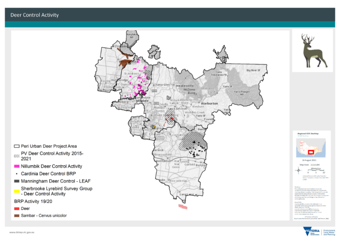
Figure 17: Deer control efforts 2015–20
Control methods are limited for deer, and it is essential to use best-practice methods such as shooting, fencing and guards, traps, and using dogs to flush deer into areas where other techniques may be used.
Non-lethal chemical deterrents have been used, but most are considered useful for short periods only (Bennett, 2020). Similarly, some hunters like to use free-feeding and attractants to lure deer to an area that is suitable for shooting.
Deer are wary and may become more difficult to manage when subject to ineffective control. The choice of control methods is influenced by concerns for animal welfare, non-target impacts, public safety, occupational health and safety and restrictions (legislative and practical) on applying some techniques (e.g., use of firearms on small landholdings).
While deer control is possible in peri-urban environments, not all tools are effective, practical, or available.
The high population density in peri-urban areas and small property sizes limit the extent to which shooting can be used, including aerial and on-ground shooting for both professional and recreational hunters.
There are other considerations such as the larger number of stakeholders to engage and notify.
The use of tranquillizer guns and subsequent euthanasia of deer is considered safest by organisations such as Melbourne Zoo. The use of tranquillizer guns is restricted to authorised persons.
Effective control needs an assessment of each situation and the circumstances surrounding each problem.
Some key planning considerations for peri-urban deer control include:
- Noise from firearms discharged close to other properties.
- The difficulty of shooting deer on small properties because of buffer widths.
- The potential need for Public Place Permits.
- Ground-based shooting at sites may not be possible.
- Fragmented properties and discontinuous areas of control can lead to reinvasion from non-control sites.
- The use of recreational hunters is restricted to certain public land areas unless authorised by the land manager (Game Management Authority mapped sites indicate sites possible to hunt).
- Lack of community awareness - limited knowledge of deer, and signs of their presence, impacts and options for control and management.
- Variable ownership of the problem that deer cause.
- Knowledge gaps about deer distribution and impacts in peri-urban areas.
- Disposal of deer carcasses can be more difficult.
Control methods and responding to peri-urban considerations are covered in more detail in the:
Note, a Standard Operating Procedure for deer control is being developed under the VDCS and will include a chapter on peri-urban deer control.
Agencies such as DELWP, Parks Victoria and Melbourne Water have staff dedicated to deer control work.
The existing capability has also been established in the aerial shooting program. It is proposed to establish specialised skills in this broader team of people.
General knowledge of deer control can be made available to DELWP and Parks Victoria field staff through a range of mechanisms. For example, recorded sessions could be made available to crews when on standby. Online forums have been used in some LGAs.
Masterclasses developed in New South Wales aim to train people in deer management and control techniques, theoretical ways to monitor and control feral deer, as well as biology and identification. A similar course is also planned for Victoria.
The Victorian Deer Control Community Network consists of government and community members interested in building the knowledge and capacity of those involved in deer control.
It is anticipated that new networks will also support capability building. Increasing community awareness around aspects of deer control is also important.
Illegal hunting can undermine the efforts of legitimate deer controllers if community awareness is absent. Cooperative actions with hunting groups can build greater knowledge.
Traditional Owners are expected to perform on-Country assessments over time. Skills development for Traditional Owners has also been identified as an activity.
Deer research underpins deer control efforts by helping us understand what works where.
Research has been identified as part of Victoria’s partnership with other states and a range of Centre for Invasive Species Solutions funded projects are underway, including those with a focus on deer. These include:
- Management of wild dog and deer in peri-urban landscapes: strategies for safe communities
- Role of wild deer in the transmission of diseases for livestock, and
- Cost-effective control of wild deer.
Melbourne Water, through its research partnership with the University of Melbourne, is also investing in research activities including developing a predictive model to understand the density and impact of deer across the region.
The $63.2 million Victorian Government investment into the Bushfire Biodiversity Response and Recovery (BBRR) program is funding research including a genetic sampling strategy for deer, aerial shooting spatial abundance modelling, monitoring the effectiveness of landscape-scale deer control to support native vegetation recovery following bushfire.
Research opportunities are also formulated at the state level through DELWP’s Biodiversity Knowledge Framework. This identifies and prioritises knowledge gaps and uncertainties related to delivering Protecting Victoria's Environment - Biodiversity 2037 – Victoria’s plan to stop the decline of native plants and animals and improve our natural environment.
The VDCS lists a range of research opportunities. Priority research themes include the establishment of deer density targets to protect key assets, further information on deer distribution and abundance, management efficacy, humane control measures, monitoring and disease risk and cost.
A key knowledge gap identified in the biodiversity knowledge framework is understanding deer density thresholds.
The partnership group identified several potential research activities for consideration:
- Kinship eDNA studies in peri-urban Melbourne to understand relatedness between deer populations and dispersal.
- Deer aggregator (Feeder tool) use to assist in the deer control program
- Research into alternative safe and effective control methods within peri-urban areas.
- Long-term effectiveness of the use of lures.
- Impact of deer densities on Ecological Vegetation Classes in peri-urban Melbourne.
- Practical cost-effective deer monitoring solutions for communities.
- Analysis of cost impacts of deer damage to agriculture.
- The proportion of a population to be culled each year to reduce population growth.
- Recolonisation rates.
- Using radio-collaring techniques to expand knowledge on deer movement.
A biosecurity approach to deer management
The Victorian Government’s approach to biosecurity is based on the return-on-investment principle, whereby the greatest return on investment is achieved through activities that prevent the entry and establishment of a species.
Where possible, prevention is the most cost-effective means of managing invasive species. The benefit–cost ratio decreases as an invasive species becomes more widespread. In areas where deer have become established, containing the population, and protecting assets may be the only options.
This is commonly represented in an invasion curve as shown in Figure 18.
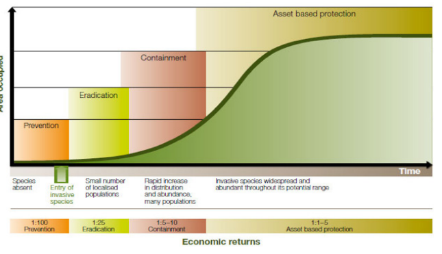
Figure 18: Invasion curve
This Plan has adopted the same Deer Control Framework as the VDCS, which is based on the biosecurity approach. The objectives of the framework are to:
- prevent new deer populations from establishing in Victoria (prevention)
- remove isolated populations of deer (eradication)
- limit the spread of deer beyond their current geographic range (containment)
- protect and reduce the impacts of deer on priority values (asset protection).
The entirety of the peri-urban region has not been strategically or systematically monitored for deer presence or impacts.
As a result, it is not yet practical to map defined areas based on the invasion curve.
The following is a summary of where and how we can apply a biosecurity approach across the peri-urban plan area, based on information gathered by the partnership group on known deer locations.
Current distribution, threat and hotspot maps show few remaining deer-free areas in the peri-urban region. More urbanised areas tend to be predominantly deer-free, but this may be because of a lack of monitoring in these areas.
Prevention areas should be monitored, and an alert raised if deer arrive in new areas. Monitoring may need to be accompanied by an education program, particularly for council officers in LGAs adjoining the peri-urban plan area and government staff, to ensure they know how to look for deer signs.
Control of deer on extremities of known deer populations is a distinct opportunity as deer distribution is expanding. If isolated individuals continue to appear, prompt treatment is suggested. Often the early signs are ignored as a few deer are tolerated, even seen as a novelty by some. Collective awareness and support to get control as soon as new sites are recognised will lead to long-term benefits.
The western boundary of the peri-urban plan area should act as a containment line, with deer prevented from establishing any closer to the metropolitan Melbourne.
In some instances, where deer are known to be nearby, the strategic location of fences on known movement corridors might redirect deer and prevent them from accessing new habitats.
Removing all deer from an area and subsequently preventing new deer from recolonising – is possible in areas where deer are contained or isolated either by fencing or distance to other forested areas.
A few isolated pockets of deer in the peri-urban plan area have been flagged for eradication, including a small herd of Fallow deer in Plenty Gorge Park, and large numbers of Red and Sambar deer contained in large, fenced reservoir areas.
Where possible, these small, contained populations should be eradicated using professional or volunteer deer controllers and fences checked and strengthened, or installed around any critical habitat areas to prevent further access.
The actual cost per individual deer can be greater when deer populations are minor compared to times when large numbers of deer are present. Numbers alone should not account for decisions about deer treatment.
The biosecurity approach in removing deer at the early stage of invasion can reap long term benefits.
The westernmost LGAs in the peri-urban plan area are the most urban locations where deer would normally be found, with large enough patches of vegetation to sustain deer populations.
Many of these habitat areas are located around the Yarra River and its tributaries. Because these waterways are the main corridors of movement, they should be monitored closely. Strategic locations identified where deer can be cut off, and further spread contained.
Recent media showed Sambar deer in Kew, Ivanhoe, Bundoora, and Fitzroy, in front gardens, golf courses, along the Yarra and running down main roads. While the river corridor is narrow, there are several larger parks in which Sambar deer could easily persist and breed, causing concerns for public safety.
Monitoring stations are needed along the Yarra River to prevent more deer venturing towards the city, but also along major tributaries such as the Plenty River and Mullum Mullum Creek, to track movement and numbers.
Monitoring sites should also be established on corridors leading out of larger reserves with known deer presence including Yarra Ranges National Park, Bunyip State Park, Dandenong Ranges National Park, Churchill National Park, Yellingbo Nature Conservation Reserve and Kinglake National Park.
Strategic control points can be difficult to find in areas of higher urbanisation and can be difficult because of access and dense vegetation. As many of these tributaries are found on private land and adjoining public land, LGAs should work closely with public land managers to determine key sites along movement corridors for effective control.
Cooperative partnerships between both private and public land managers will help provide opportunities for control and other management options in sites identified as the main corridors of movement.
Where deer are established and in large numbers, ground-based shooting programs alone may not be effective. They will be more effective if combined with other control and management techniques.
Aerial shooting can be effective in managing large numbers of deer but may not be suitable in built-up peri-urban areas.
In some circumstances, complete or immediate exclusion of deer is needed to eliminate impacts and to prevent significant or irreversible damage to critical habitats and other assets.
Ground-based deer control will reduce deer numbers over time, but exclusion fencing can provide instant protection to threatened flora, orchards and vineyards when needed. Permanent protection of key assets supported by deer control and monitoring on a landscape scale will help reduce deer damage.
Deer exclusion fences have been successful in a range of locations such as in the One Tree Hill Reserve (Smiths Gully) to protect small populations of endangered Rosella Spider-orchids (Caladenia rosella) and their pollinator plant species.
It should be acknowledged that a focus on asset protection is sometimes a product of limited budgets. If funds cannot achieve an appropriate reduction in deer to eliminate deer impacts, permanent protection should be considered in small areas, followed by a long-term control program to gradually reduce deer densities.
Deer-proof fences can be constructed to allow the continued or seasonal passage of native fauna. They also provide an opportunity to monitor how vegetation responds to excluding large herbivores.
Prioritising locations for deer control
A key objective of this Plan is to guide investment and collaborative on-ground action for the greatest net benefit across multiple values and land tenure. Actions that provide the greatest net benefit to biodiversity, in accordance with Biodiversity 2037 across all land types will be prioritised.
Various data sources have been used to map where the potential impacts of deer on values and threats are highest in the peri-urban plan area. Figure 19 shows the priority investment locations based on this mapping.
This map is designed to be used with the prioritisation matrix to assess whether investing in deer control is worthwhile at specific locations. Land managers can use these tools to identify cost-effective and strategic locations to carry out deer control, surveillance, and other management measures at a local level.
The prioritisation matrix helps narrow down the best sites for deer control and management projects both within mapped priority investment locations and at non-mapped sites if sufficient impacts on values and threats can be shown.
Some sites may also be prioritised based on values or threats present on adjoining land, where it can be clearly shown that works carried out at a site will directly benefit values or threats in the neighbouring area.
Some sites may also be prioritised based on values or threats present on adjoining land, where it can be clearly shown that works carried out at a site will directly benefit values or threats in the neighbouring area.
Figure 19: Map of priority investment locations in the peri-urban area
Appendix 2 shows the data layers used to develop this map.
The three-step approach in Figure 20 outlines how to identify areas for cost-effective deer control at both the LGA and site-level using the priority mapping and prioritisation matrix.
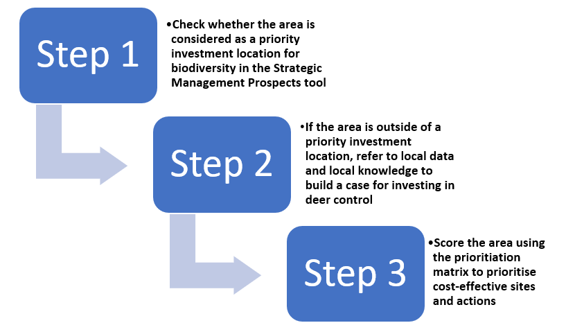
Figure 20: Three-step approach to identify areas for cost-effective deer control
The matrix scores and ranks the following attributes:
- invasion curve – current and potential deer distributions and impacts
- biodiversity, agricultural, water and cultural values
- public safety including road safety
- sites where deer control would benefit the most native flora and fauna species, and
- areas where interventions are cost-effective.
The mapping that supports the matrix is likely to be updated over time. A web-based system with interactive mapping layers may be available in the future, enabling land managers to view their area of interest and determine priority areas for deer control.
In the interim, some printed maps are provided in Appendix 2 – Mapping priority areas – and A3 maps can be found in Peri-Urban Deer Control Plan Maps.
Criteria | Category | Possible Score |
|---|---|---|
Invasion curve (Select only one of the following) | ||
Species absent | Prevention | 15 |
Small number of localised populations | Eradication | 10 |
Rapid increase in distribution and abundance, many populations | Containment | 5 |
Widespread and abundant throughout potential range | Asset-based protection | 1 |
Biodiversity values (Select only one of the following) | ||
SMP Benefit-Cost of Deer Control (BCDC) Select ONE. Value must be across > 50% of the project area BCDC ranks the cost-benefit of deer control relative to all actions across areas, on a scale of 1 (low) to 100 (high). | Low value – Score < 50% (Bottom 50%) | 0 |
Medium value – Score 50–80 (Top 50%) | 3 | |
High value – Score 80–95 (Top 20%) | 6 | |
Very high value – Score > 95 (Top 5%) | 10 | |
SMP Benefit of Deer Control (BDC) Select ONE. Value must be across > 50% of the project area BDC ranks the benefit of deer control relative to all actions across areas, on a scale of 1 (low) to 100 (high). | Low value – Score <50 | 0 |
Medium value – Score 50–70 | 6 | |
High value – Score >70 | 10 | |
Rare or Threatened Species present not accounted for in BCDC or BDC | Locally significant | 2 |
FFG / EPBC listed | 3 | |
Agricultural values (Select only one of the following) | ||
Land use (select the main land use across the site) | Not applicable | 0 |
Low value, e.g. pasture, grass | 1 | |
Medium value, e.g. fodder crop, oats, etc., plantations | 3 | |
High value, e.g. commercial strawberries, vineyard, orchards, vegetable, nursery | 5 | |
Aboriginal cultural values (Select only one of the following) | ||
Sites of cultural significance – including waterway buffers, scar trees, etc. | No sites | 0 |
Sites and/or waterway buffers – medium value | 4 | |
Many sites and/or waterway buffers – high value | 10 | |
Water values (Select only one of the following) | ||
Quality waterways, habitat areas for threatened aquatic or dependant species, water supply areas | Not in the water area | 0 |
Identified on map | 3 | |
High value - chlorine only, Silvan, Cardinia, Upper Yarra | 5 | |
Habitat restoration (including permanent protection sites) | ||
Recent restoration or revegetation work on-site / in the project area | No | 0 |
Yes | 2 | |
Safety – vehicle collisions (Select only one of the following) | ||
Collision reports from Davies et al., LGA supplemented records or Wildlife Victoria collision report data by suburb – based on 12 months | None recorded | 0 |
Low (1) | 1 | |
Medium (2–5) | 3 | |
High (>5) | 5 |
FFG = Flora and Fauna Guarantee Act 1988
EPBC = Environment Protection and Biodiversity Conservation Act 1999
The following factors also need to be considered when choosing priority sites, where relevant.
This will ensure that proposed actions are relevant and the best option to achieving objectives, and projects are well planned.
These factors will be used to help guide DELWP investment.
- Are the proposed works appropriate for the invasion curve stage being addressed?
- How successful were previous works on that site or in the immediate area?
- How feasible are the proposed works on the site?
- Does the community support the works (particularly where participation of private landholders is needed)?
- Are there any cross-tenure works with adjoining land managers?
- Can applicants deliver the project within specified timeframes and budgets?
- Is the project area large enough to deliver landscape-scale benefits and/or provide direct benefit to individual flora or fauna species to be protected?
- Is there robust monitoring to measure project effectiveness?
- Is there scope to integrate with other pest plant and animal programs such as concurrent pig, goat, or fox control, or weed control to offset any increased weediness following removal of herbivores?
- Are movement corridors and 'feeder locations' included? These may not rank highly in terms of impact on values but need to be considered in the strategic management of deer across the Plan's footprint.
Improving deer control in the peri-urban area
This Plan identifies a range of priority actions designed to improve the control of deer in the peri-urban plan area. Actions will be implemented over the five-year life of the Plan.
Actions are aligned to the goals of this Plan and the VDCS. Some actions may impact multiple goals.
No. | Action | Purpose |
|---|---|---|
1.1 | Undertake deer control and management activities in priority locations | Guided by this Plan, DELWP will invest in and lead deer control to reduce deer at priority sites. |
1.2 | Develop collision register for deer–vehicle accidents | Mapping deer–vehicle collisions (DVCs) is a useful tool to locate potential deer hotspots on roads. Creating a collision register for community use would tap into citizen science to help find more deer hotspots. |
1.3 | Undertake deer control at Melbourne Water identified priority waterways and water supply network sites | Targeted control programs in closed (fenced) catchments will aim to eradicate deer at high priority locations. Scheduled deer control by Melbourne Water is already contributing to reduced deer numbers at some of these identified locations. |
1.4 | Work with partnership members to support the use of deer carcasses | Being able to ‘drop and leave’ deer carcasses can increase control efficiencies and may be considered in areas where decomposing animals will not cause community concerns or water quality issues. However, small properties in peri-urban areas may not be suitable to leave deer in situ without upsetting neighbours due to the smell or sight. An increasing number of professional deer controllers are also licensed harvesters, which enables the removal and commercial processing of wild shot deer for human consumption or pet food through PrimeSafe licensed game meat processing facilities. |
1.5 | Control deer before planting, revegetation or establishment of plantations and as ongoing activity. | Land managers may reduce vegetation losses by conducting effective deer control before establishing new plantings. |
1.6 | Map deer fencing in the peri-urban area to support deer control planning | Fencing is best suited to protecting spatially discrete high-value assets. Eradication of deer within fenced plots may be possible, so mapping deer fencing may help with planning future control programs. |
1.7 | Undertake a yearly review of the Regional Plan | The partnership group will review this Plan once a year to keep it current. New deer incursions will be incorporated into mapping and progress against actions will be assessed. |
| No. | Action | Purpose |
|---|---|---|
2.1 | Build capacity to protect Aboriginal cultural heritage through Traditional Owners | While sensitive Aboriginal cultural heritage sites have been mapped, ongoing monitoring is needed to provide protection. The mapping in this Plan and further conversations with TOs can provide additional insights to identify areas for future protection. Increasing knowledge on deer for the whole community including TOs will lead to future benefits for values and is one of the aspirations of the Plan. Training can help to increase knowledge on deer control and lead to greater protection of high-value areas. |
2.2 | Review role of government in supporting standard accreditation process for shooters | Adopting standard processes can lead to increased confidence in the capability of shooters. |
2.3 | Hold yearly masterclass for deer control | Masterclasses developed in New South Wales are planned to be extended to Victoria to build further capability of government, partners, and community. |
2.4 | Increase community understanding of deer impacts and control options through collaborative programs | Increased support for control programs and ownership of ongoing control actions and participation. |
| 2.5 | Install demonstration deer fences and shooting platforms | Demonstration sites will be set up to share information and show examples of fences and shooting aids such as platforms. Other mechanisms and examples of their use to help in deer management and control are envisaged. Regular reviews of options will occur through consultation with stakeholders. |
No. | Action | Purpose |
|---|---|---|
3.1 | Develop and share deer density monitoring methodology for the peri-urban landscape | Deer abundance research gives land managers a view of the density of deer but is incomplete in various parts of the state, including in peri-urban Melbourne. Deer distribution modelling is an important component of the Strategic Management Prospects tool to help guide prioritisation of deer control locations. |
3.2 | Quantify impacts of deer on agricultural enterprises in peri-urban areas | Quantifying and mapping the economic impact of deer across the range of agricultural enterprises will help prioritise targeted deer control at sites of greatest impact. |
3.3 | Develop and promote a Ground Shooting Standard Operating Procedure (SOP) for deer control in peri-urban areas | Shooting can be a humane method of culling deer when carried out by experienced, skilled, professional and responsible shooters. A ground shooting SOP will lead to consistent approaches in this method of deer control. |
3.4 | Contribute to research priorities by identifying knowledge gaps | Deer research helps land managers better understand what actions work where. Increased participation in collaborative research projects and the development of new research partnerships focussing on key research gaps will improve the understanding of deer within the landscape. |
3.5 | Enhance citizen sciences for deer program | Identifying and mapping deer activity and sightings can support the broader program. Community members can add records to systems such as the Atlas of Living Australia, or through mobile apps such as FeralScan. |
3.6 | Support mitigation measures including signs, deterrent devices, and media to reduce impacts of deer and increase community awareness of deer and control options | Strategic placement of signage along roads and in public recreational areas will raise community awareness of the safety risks from deer on roads and during rut seasons when stags may become more protective. Information collected for road collisions and near-misses with deer will help inform signage placement. This data can be collected using cameras and through individuals reporting into existing systems and the collision register once developed. (Action 1.2) |
Implementation
Table 1 outlines a range of actions designed to target areas considered as important by the partnership group
Action: 1.1 Undertake deer control and management activities in priority locations
VDCS ref 1.3.1
| Result | Lead | Partners | Timeframe priority | KPI | Objective (VDCS) |
|---|---|---|---|---|---|
| Reduction in the abundance of deer and protection of assets within priority sites | DELWP | TOs, PV, LGA, MW | Yearly | Hectares of control at priority sites | Undertake strategic deer control |
Action 1.2 Develop collision register for deer-vehicle accidents
VDCS ref 1.6.1, 3.2.4
| Result | Lead | Partners | Timeframe priority | KPI | Objective (VDCS) |
|---|---|---|---|---|---|
| Collision registers are available for public use | DELWP | Various | June 2023 | Increased mapping of hotspots to improve public safety | Reduce public safety risks associated with deer |
Action 1.3 Undertake deer control at Melbourne Water identified priority waterways and water supply network sites
VDCS ref 1.3.1
| Result | Lead | Partners | Timeframe priority | KPI | Objective (VDCS) |
|---|---|---|---|---|---|
| Water supply networks protected | MW | PV, DELWP, Adjacent land managers | 2021–23 Yearly | Reduction in the abundance of deer. Eradication at Silvan and Cardinia reservoirs by June 2026 Increase in water quality | Undertake strategic deer control |
Action 1.4 Work with partnership group members to support the use of deer carcasses
VDCS ref 1.5.1
| Result | Lead | Partners | Timeframe priority | KPI | Objective (VDCS) |
|---|---|---|---|---|---|
| Increased use of deer carcasses | DELWP | PV, MW, LGA, AgVic | Yearly and as needed | 10% increase in the use of deer carcasses | Contribute to deer harvesting where possible |
Action 1.5 Control deer before planting, revegetation or establishment of plantations and as ongoing activity
VDCS ref. 2.3.2
| Result | Lead | Partners | Timeframe priority | KPI | Objective (VDCS) |
|---|---|---|---|---|---|
| Plant losses from deer browsing, grazing and tree rubbing are reduced | Land manager | Various | Yearly | Increase in tree establishment and increase plantation returns | Encourage hunters and commercial harvesters to contribute to strategic and cost-effective control programs |
Action 1.6 Map deer fencing in the peri-urban area to support the planning of deer control
VDCS ref 1.3.1
| Result | Lead | Partners | Timeframe priority | KPI | Objective (VDCS) |
|---|---|---|---|---|---|
| Maps available for future use in planning. Provide an opportunity for deer impact study through vegetation assessments | LGA | PV, Various | Yearly | Number of LGA areas mapped | Undertake strategic deer control |
Action 1.7 Undertake an annual review of Regional Plan
VDCS ref 1.2.1
| Result | Lead | Partners | Timeframe priority | KPI | Objective (VDCS) |
|---|---|---|---|---|---|
| Updated mapping, results reported, and actions modified as needed | DELWP | Partnership group | Yearly | Review completed by end of each calendar year | Implement the Deer Control Framework to guide Victorian Government and partner investment in deer control |
Action 2.1 Build capacity to protect Aboriginal cultural heritage values through Traditional Owner groups (TOs)
VDCS ref. 2.2.1, 2.2.2
| Result | Lead | Partners | Timeframe priority | KPI | Objective (VDCS) |
|---|---|---|---|---|---|
Reviews show better mapping Protection of Aboriginal values TO capacity building in strategic deer control | TOs, DELWP, PV | Various | June 2022 then yearly | Number of TO groups involved in projects. Number of sites identified. % of procurement directed to TOs | Enhance Traditional Owner involvement in deer control |
Action 2.2 Review role of government in supporting standard accreditation processes for shooters
VDCS ref. 3.2.3
| Result | Lead | Partners | Timeframe priority | KPI | Objective (VDCS) |
|---|---|---|---|---|---|
| Collaboration and partnership | DELWP | DJPR, PV, MW, LGA, ADA, SSAA | June 2022 | Review completed by June 2022 | Develop a Standard Operating Procedures and a Code of Practice for the control of deer to assist land managers |
Action 2.3 Hold yearly masterclass for deer control
VDCS 2.1.1 and 3.4.1
| Result | Lead | Partners | Timeframe priority | KPI | Objective (VDCS) |
|---|---|---|---|---|---|
| Increased knowledge of deer management. More practitioners upskilled in control, trapping and other deer management techniques | Organising committee | Land managers | May each year, starting 2022 | Number of participants | Provide leadership and coordination through strategic partnerships Partner with other jurisdictions to share knowledge, co-invest in research and build capacity |
Action 2.4 Increase community understanding of deer impacts and issues through collaborative programs
VDCS ref. 2.3.2, 3.2.2
| Result | Lead | Partners | Timeframe priority | KPI | Objective (VDCS) |
|---|---|---|---|---|---|
| Better educated practitioners and community on deer | DELWP | Various | Yearly | Number of collaborative programs and educational forums |
Encourage hunters and commercial harvesters to contribute to strategic and cost-effective control programs.
Enhance knowledge and best practice management of deer |
Action 2.5 Install demonstration deer fences and shooting platforms
VDCS ref 3.2.2
| Result | Lead | Partners | Timeframe priority | KPI | Objective (VDCS) |
|---|---|---|---|---|---|
| Increased adoption of tools | DELWP | Various | 2 per year | Visits, adoption, km of fences | Enhance knowledge and best practice management of deer |
Action 3.1 Develop and share deer density monitoring methodology for the peri-urban landscape
VDCS Ref 3.5
| Result | Lead | Partners | Timeframe priority | KPI | Objective (VDCS) |
|---|---|---|---|---|---|
| Consistency in monitoring | DELWP | ARI, PV, LGA | March 2020 | Use of methodology | Ensure monitoring and evaluation outcomes continue to inform and improve management |
Action 3.2 Quantify impacts of deer on agricultural enterprises in peri-urban areas
VDCS ref 2.4
| Result | Lead | Partners | Timeframe priority | KPI | Objective (VDCS) |
|---|---|---|---|---|---|
| Deer control is targeted to areas of greatest impact | Partnership group | Stakeholders | June 2022 | Data available to show the impacts of deer. Data sought from 25% of area each year | Ensure a consistent and collaborative approach across Plan state (regional) boundaries where possible |
Action 3.3 Incorporate a Ground Shooting Standard Operating Procedure (SOP) for deer control in peri-urban areas into all government-funded works and encourage community use.
VDCS Ref. 1.6.2, 3.2.3
| Result | Lead | Partners | Timeframe priority | KPI | Objective (VDCS) |
|---|---|---|---|---|---|
| Increased efficiency in the implementation of deer control shooting | DELWP, PV, MW | DJPR, communitty | As required | 100% implementation across government-funded projects by June 2023 SOP used by community | Reduce public safety risks associated with deer Ensure monitoring and evaluation outcomes continue to inform and improve management |
Action 3.4 Contribute to research priorities by identifying knowledge gaps
VDCS ref 3.2.1
| Result | Lead | Partners | Timeframe priority | KPI | Objective (VDCS) |
|---|---|---|---|---|---|
| Increased support and improved understanding | DELWP | Partnership group | Once opportunities are identified | Increased mapping of hotspots to improve public safety | Partner with other jurisdictions to share knowledge, co-invest in research and build capacity |
Action 3.5 Enhance citizen sciences for deer program
VDCS ref 3.2.4
| Result | Lead | Partners | Timeframe priority | KPI | Objective (VDCS) |
|---|---|---|---|---|---|
| Contribute to effort to manage and monitor deer | DELWP | Various | Ongoing | Number of participants in forums and research activities. Number of deer reports submitted | Enhance knowledge and best practice management of deer |
Action 3.6 Support mitigation measures including signs, deterrent devices, and media to reduce impacts of deer and increase community awareness of deer and control options
VDCS ref 3.2.2
| Result | Lead | Partners | Timeframe priority | KPI | Objective (VDCS) |
|---|---|---|---|---|---|
| Best practice guides underpin decision-making | DELWP, LGA, PV | RRV | Annually |
Number of devices in use and number of media comms | Enhance knowledge and best practice management of deer |
Lead and partner key
| ADA | Australian Deer Association | MW | Melbourne Water |
| AgVic | Agriculture Victoria | NSW | New South Wales |
| ARI | Arthur Rylah Institute | PV | Parks Victoria |
| CMA | Catchment Management Authority | RRV | Regional Roads Victoria |
| DELWP | Department of Environment, Land, Water and Planning | TOs | Traditional Owners |
| DJPR | Department of Jobs, Precincts and Regions | SOP | Standard Operating Procedure |
| LGA | Local Government Area | SSAA | Sporting Shooters Association Australia |
Measuring success and continuous improvement
Success will be measured through the KPIs listed in the Implementation section (see Table 1) and through ongoing monitoring of deer numbers.
In 2021, the Victorian Government started a process to monitor deer at more than 100 sites across Victoria. Local control actions will include monitoring to supplement this broader program.
Regional deer control plans will be updated every five years but will also be reviewed yearly as part of a continuous improvement cycle. This will ensure that decisions on where to invest in deer control are based on the latest information.
The partnership group will convene quarterly to assess progress on the actions.
A monitoring, evaluation, review, and improvement (MERI) plan for the VDCS at the state level is in development. It is intended to provide adaptive, effective, and transparent management of the Victorian Deer Control Program.
It will outline the framework for collection and analysis of the information needed to assess whether the strategy is meeting its goals.
Reporting on the objectives, actions and KPIs of this Plan will contribute to state-level MERI reporting but also provide a basis to adjust this Plan.
This Plan will be monitored by reviewing state and local actions.
Deer density/abundance and impacts on vegetation are being monitored at a state level by the Arthur Rylah Institute (ARI) at 100 randomly selected sites as part of the overall Victorian Deer Control Program. Local project monitoring is likely to include both treatment and non-treatment sites including places where no action is taken to compare results).
ARI’s broad-scale deer monitoring program includes the following objectives:
- Assess the abundance and distribution of the major deer species including Sambar, Fallow, Red, Hog) at subregional, regional, and statewide scales.
- Monitor vegetation components impacted by deer including woody species diversity/stem density, canopy recruitment) to assess ecological integrity at subregional, regional, and statewide scales.
- Assess trends in deer abundance, distribution and impacts on biodiversity at subregional, regional, and statewide scales.
- Composition of indicators of regional and statewide deer population trends and ecological integrity suitable for use in the Australian Government’s State of the Environment reporting.
- Program data is used as input into regional MERI frameworks as well as Biodiversity 2037.
Key performance indicators in MERI frameworks include governance, stakeholder participation, compliance with deer control guides and rules, communication and engagement targets, the capacity of partners in deer control, data sharing and impact reduction.
To be successful, monitoring needs to be designed to produce consistent results and be comparable across areas of interest.
It may not be possible to monitor everywhere because of cost or available capacity. The techniques used will vary according to the need and the area of interest and large geographic areas may use sample points rather than measure the entire area.
Detailed monitoring of deer control outcomes is being improved based on knowledge from established projects in other parts of the state. Community engagement should also be included in this monitoring.
Deer detection rates tend to decline if very few are present and become more frequent as densities increase. Damage to vegetation may be less visible to untrained eyes.
More detailed descriptions of deer monitoring options can be found in the Guide to Monitoring Methods, included with this Plan.
Appendices
The Peri-urban Deer Control Plan 2021–26 aligns with the following principles from the VDCS:
- Recognition that deer populations and impacts have increased significantly in recent years.
- Recognition that deer management is a shared responsibility involving Traditional Owners, public land private land managers, conservation and community groups, the agricultural sector, Landcare, water authorities, catchment management authorities, the commercial deer industry, hunting organisations, hunters, the community and all levels of government.
- Victoria’s biodiversity is highly valued, and the highest priority will be given to actions that provide the greatest net benefit to biodiversity across all tenures.
- Stakeholders share many values in relation to deer management and divergent stakeholder views are acknowledged and respected.
- Deer control requires a coordinated and integrated approach that is supported by scientific research, collaboration, information sharing, evidence-based planning, and on-ground action.
- Deer control is targeted and managed to ensure human safety and compliance with relevant laws and to minimise adverse animal welfare outcomes.
- Deer control will be guided by Victoria’s existing approach to investment in biodiversity (Biodiversity 2037) and biosecurity.
- Deer control is strategic, cost-effective, and adaptive.
- There is sufficient evidence on the impacts of deer to act now.
The partnership group incorporated data and information from Geographic Information Systems, organisational datasets and agency records, community apps and local knowledge.
Figure 21 shows the main map layers used to develop the priority investment locations map shown earlier in Figure 19.
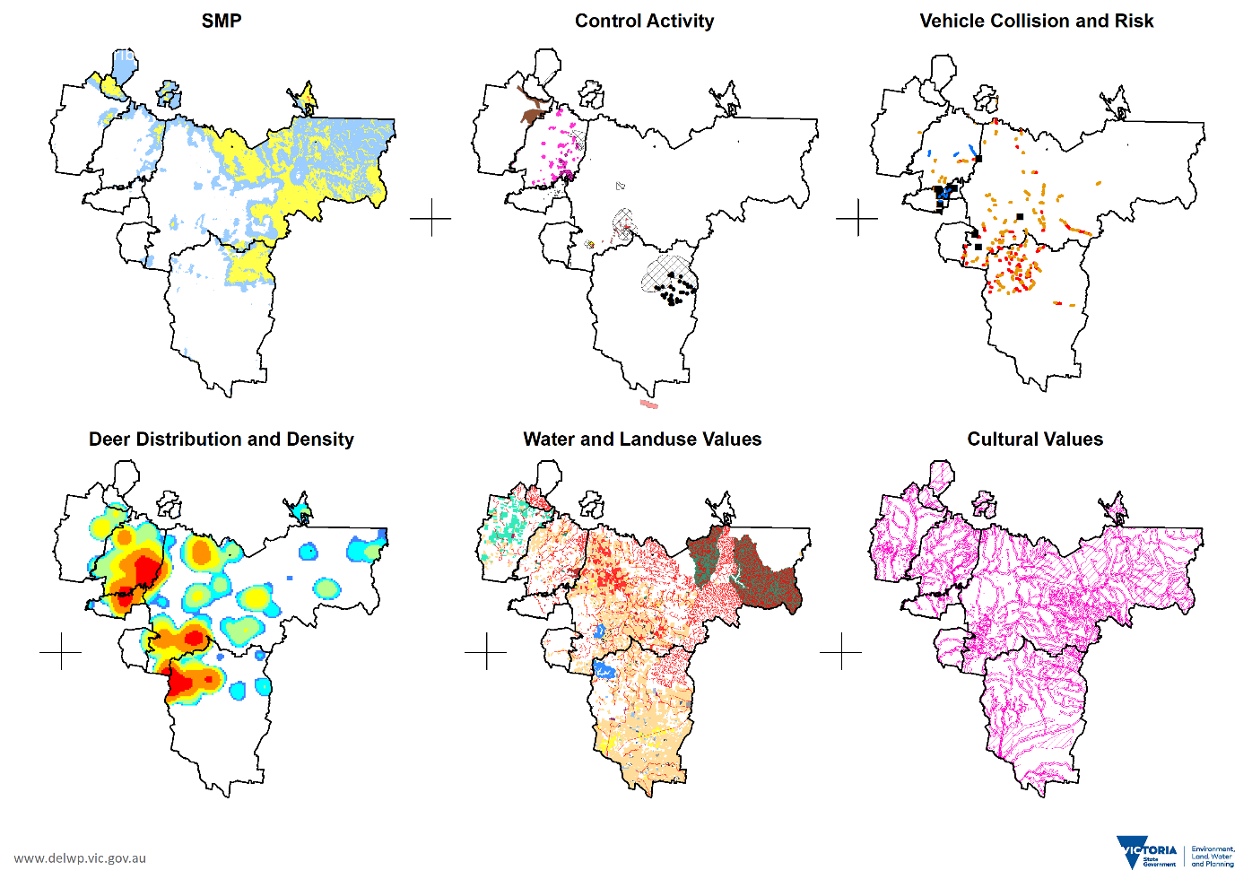
Figure 21: Layers used to map priority sites for investment in the peri-urban plan area
Strategic Management Prospects (SMP)
SMP helps biodiversity managers consider and compare which actions are needed and where to use them. It can be used to generate maps that display priority locations for deer investment at a statewide, regional, and local scale.
SMP provides an overview of the areas where deer control actions will provide the greatest return on investment and benefit the most species across Victoria.
SMP has maps of the benefit and benefit-cost of deer control. When using the prioritisation matrix, only one of these maps should be used to score biodiversity values, not both. Figure 22 shows the deer control benefit-cost map, as an example.
Benefit-cost of deer control
Understanding the relative amount of benefit to cost (the benefit-cost ratio) is essential to getting the most from the resources available.
Some management actions which could provide high benefits may have high costs and not be affordable across large areas. Some actions are cheap but may or may not be strongly beneficial. Some actions may have moderate costs and deliver moderate benefits but to many species.
SMP shows the cost-effectiveness of actions through a benefit-cost ratio using estimates of specific actions at specific locations with their expected benefit.
SMP deer control benefit-cost map (Figure 22) shows where deer management actions will be most beneficial with the best benefit-cost ratio. It shows the top 5, 20 and up to 50% benefit–cost locations across the peri-urban plan area.
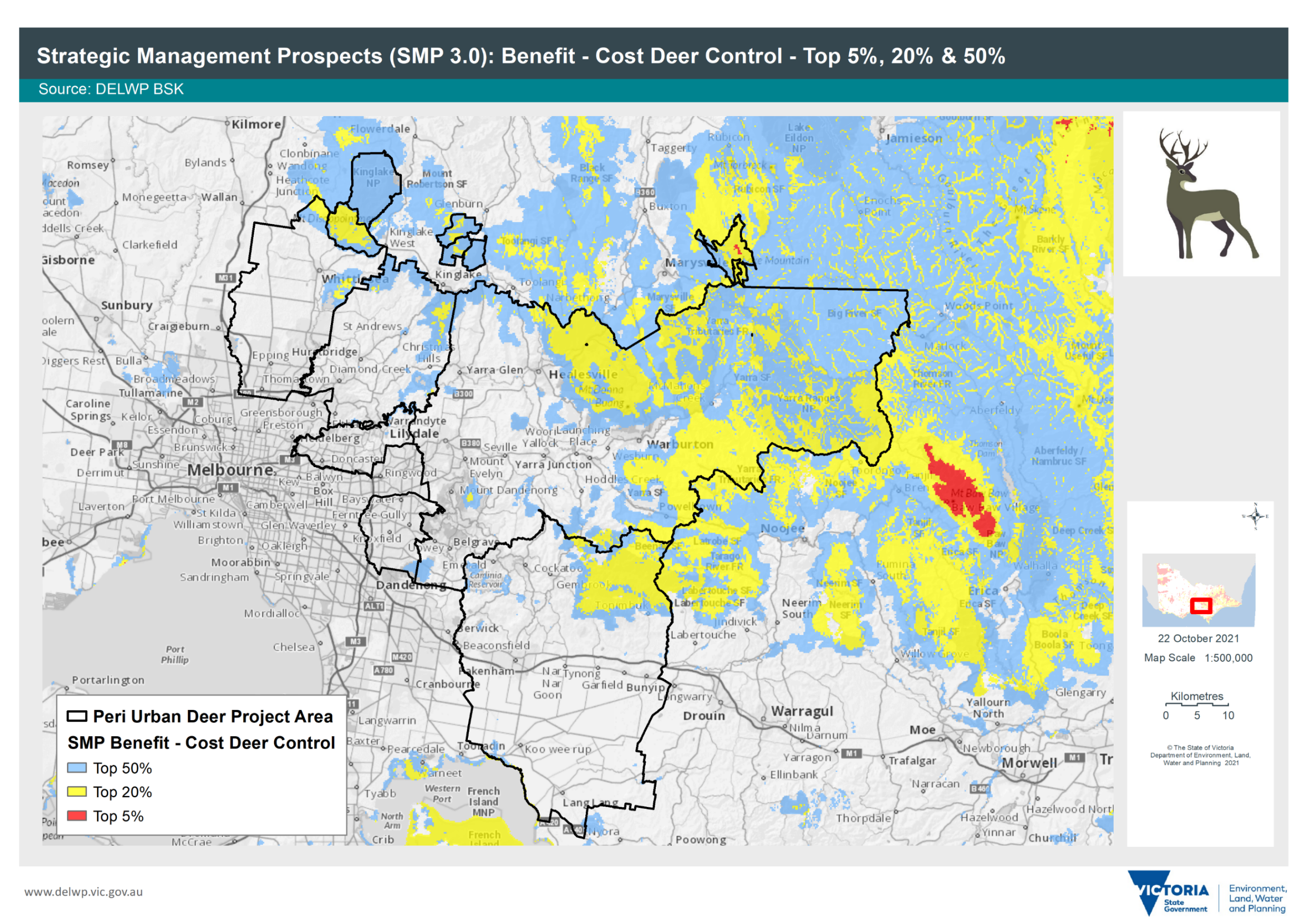 Figure 22: SMP benefit-cost of deer control in the peri-urban plan area
The benefit of deer control
SMP deer control benefit map shows where and to what extent deer management actions could benefit the most species of plants and animals in various locations (Figure 23).
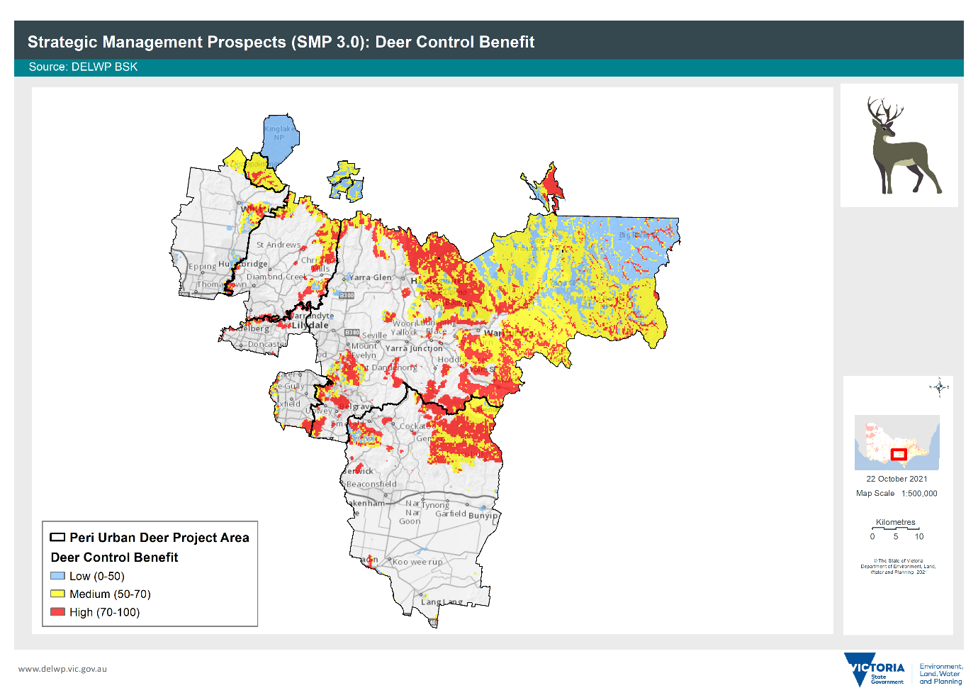
Figure 23: SMP deer control benefit map – darker shades reflect greater biodiversity benefits from deer control
Rare and threatened species
There are some gaps in the existing SMP layer. Aquatic invertebrates are excluded. Some locally significant threatened species are not captured because of the scale of mapping, although their locations are entered into the Victorian Biodiversity Atlas. To account for this gap, rare or threatened species can be scored in the prioritisation matrix where they are not represented in SMP mapping.
Control activity
Control activity maps indicating recent deer control works, aligned with current deer distribution, and located around key assets for protection (e.g., water reservoirs) and along fringe areas of public land and conservation reserves. See Current deer control efforts for mapping.
Vehicle collision and risk
Deer–vehicle collision (DVC) risk and road collision incidents are depicted and use information (based on council records), Davies et al. (2020) study into predicting DVC-risk areas and DVCs recorded in the Wildlife Victoria online tool. Refer to Deer–vehicle collisions and actual road collisions for DVC mapping.
Deer distribution and density
Victorian Biodiversity Atlas (VBA)
The VBA species observations show where wildlife is now and how this has changed over time. It is a foundational dataset that feeds into many biodiversity tools (including SMP) used in everyday decision-making and is a core input to most of the Government’s processes and programs that impact native species.
Adding information to the VBA is the preferred method for recording information on deer. If FeralScan or the Atlas of Living Australia is used, SMP will look at these other data sites for information to update maps.
Community members can improve deer data by logging deer sightings on the VBA.
Atlas of Living Australia (ALA)
The ALA is a collaborative, digital, open infrastructure that pulls together Australian biodiversity data from multiple sources, making it accessible and reusable.
The ALA helps to create a more detailed picture of Australia’s biodiversity for scientists, policymakers, environmental planners and land managers, industry, and the public.
Community members can improve deer data by logging deer sightings on the ALA.
FeralScan is a free resource for landholders, Landcare groups, community groups, local councils, professional pest controllers and biosecurity groups. It has been designed by landholders for communities to log animal sightings either directly on the website or through the mobile app.
Water and land use values
Water values mapped are priority reservoirs for control to protect the potable water supply, as well as high-quality waterways and riparian areas providing habitat for threatened aquatic or dependant species.
Classifying land use
To prioritise land use areas for deer control, agricultural areas were ranked as high, medium, and low based on the financial burdens that would be experienced and the impacts of deer on the enterprise type and recovery time (Table 2 and Figure 24).
For instance, deer damage in an orchard or vineyard could result in the loss of an entire year’s crops and income and grazing of pasture might require farmers to buy supplementary feed for stock or to reduce stocking rates.
Table 2: Land use rankings
The financial burden of deer | Land use |
|---|---|
Low | Glasshouse Plant / Vegetable Production, Outdoor Sports – Extended Areas/Cross Country, Outdoor Sports Grounds – town or suburban facilities, Outdoor/Indoor Sports Complex – non-major, Poultry – Open Range, Poultry (egg production), Poultry (broiler production) |
Medium | Domestic Livestock Grazing, Horse Stud / Training Facilities/Stables, Livestock Grazing, Equestrian Centre, Mixed Farming and Grazing, Mixed farming and grazing (generally more than 20 ha), Native Hardwood (standing timber), Non-native Animals, Piggery |
High | Market Garden – Vegetables, Orchards, Groves and Plantations, Plant / Tree Nursery, Specialised Cropping, Softwood Plantation, Vineyard, Livestock Production – Sheep, Livestock Production – Dairy Cattle, Livestock Production – Beef Cattle, Hardwood Plantation, General Cropping (generally more than 20 ha plantings), Forestry – Commercial Timber Production, Commercial Flower and Plant Growing (outdoor), Sport, Heritage and Culture |
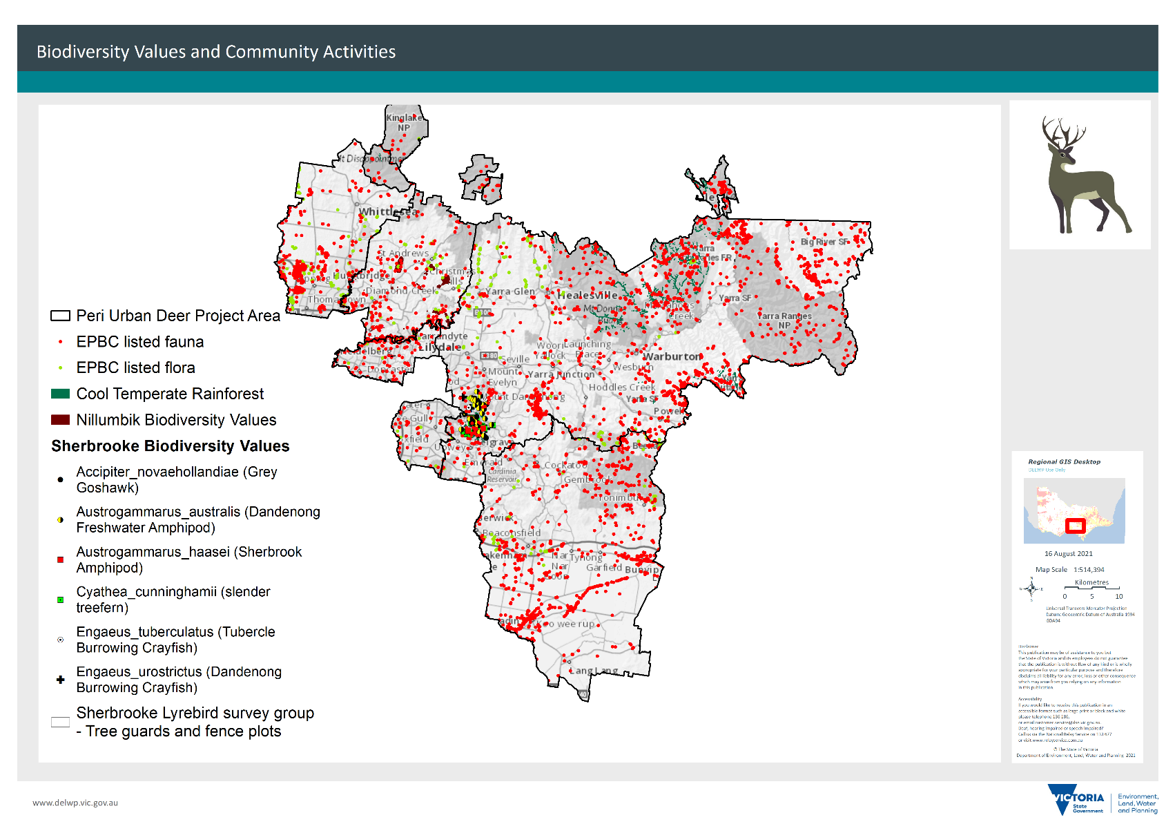
Figure 24: Land use in the peri-urban plan area
Aboriginal cultural heritage values
Aboriginal cultural heritage mapping is not publicly accessible because it contains sensitive information.
The Aboriginal Cultural Heritage Register and Information System (ACHRIS) can be accessed by certain people or organisations who need detailed information on cultural heritage places and objects to protect and manage them.
Sites are often found along waterways, so all stream verges are buffered to flag likely areas of sensitivity.
Consideration should be given to cultural heritage where ground layers are being disturbed.
The mapping provided in this Plan is desensitised to protect asset locations.
Land managers are encouraged to speak with their local Registered Aboriginal Party if they suspect that they may have located a scar tree or other significant site. Such sites are at risk from deer through antler rubbing of scar trees or wallowing in scatters.
References
Bennett, A (2008) The impacts of sambar (Cervus unicolor) in the Yarra Ranges National Park [PhD thesis], Department of Zoology and Department of Forest and Ecosystem Science, University of Melbourne, accessed 4 November 2021.
Butt, C (8 May 2016) The animal that causes the most car crashes in Victoria, RACV data in The Age, accessed 4 November 2021.
Davies, C, Wright, W, Hogan, F, Visintin, C (2020) Predicting deer–vehicle collision risk across Victoria, Australia, Australian Mammalogy, Vol 42(3):293–301.
Davis, E.D, Bennett, A, Forsyth, D.M, Bowman, D.M.J.S, Lefroy, E.C, Wood, S.W, Woolnough, A.P, West, P, Hampton, J.O, Johnson, C.N (2015) A systematic review of the impacts and management of introduced deer (family Cervidae) in Australia, Wildlife Research, 43. 515. 10. 1071/WR16148.
Hampton, J and Davis, N (2020). Impacts of introduced deer in Victoria, Victorian Naturalist, 137(6):276–281.
Keith, D and Pellow, B (2005) Effects of Javan rusa deer (Cervus timorensis) on native plant species in Jibbon-Bundera area, Royal National Park, New South Wales.
Murphy, A.H, White, M and Downe, J (2006) National Recovery Plan for the Shiny Nematolepis wilsonii, Department of Sustainability and Environment, accessed 4 November 2021.
Peel, B, Bilney, Rohan J and Bilney, Roger J (2005) Observations of the ecological impacts of sambar Cervus unicolor in East Gippsland, Victoria, with reference to destruction of rainforest communities, The Victorian Naturalist, 122(4):189–200.
Ramp, D & Roger, E (2008) ‘Frequency of animal-vehicle collisions in NSW’, in Too close for comfort: contentious issues in human-wildlife encounters, Royal Zoological Society of NSW, 10.7882/FS.2008.017:118–126.
Rowden, P.J, Steinhardt, D.A, Sheehan, M.C (2008) Road crashes involving animals in Australia, 40(6):1,865–71.
Sunrise Exchange News (2007) Animals increase vehicle claims costs, insurancenews.com.au, accessed 17 November 2021.
Abbreviations
ADA | Australian Deer Association |
ALA | Atlas of Living Australia |
AgVic | Agriculture Victoria |
ARI | Arthur Rylah Institute |
DELWP | Department of Environment Land Water and Planning |
DJPR | Department of Jobs, Precincts and Regions |
ERPAN | Eastern Region Pest Animal Network |
EVC | Ecological Vegetation Classes |
FOV | Field of view |
GIS | Geographic Information Systems |
KPI | Key Performance Indicator |
LEAF | Local Environment Assistance Fund |
LGA | Local government area |
MERI | Monitoring Evaluation Review and Improvement |
MW | Melbourne Water |
NSW | New South Wales |
PV | Parks Victoria |
RRV | Regional Roads Victoria |
SMP | |
SOP | Standard Operating Procedure |
TO | Traditional Owner |
VBA | Victorian Biodiversity Atlas |
VDCS | Victorian Deer Control Strategy |
Page last updated: 29/06/26