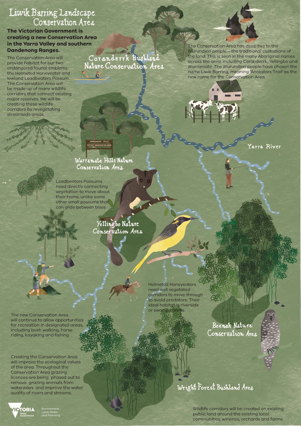
The Victorian Government is creating a new conservation area in the Yarra Valley and southern Dandenong Ranges by using existing public land. This new conservation area is known as the Liwik Barring Landscape Conservation Area.
The conservation area will provide improved water quality and habitat for critically endangered species and open new areas up for recreation.
Stay up to date by subscribing to the Liwik Barring E-Newsletter
New name for the conservation area
Feedback received from the community in recent years has suggested that the name Yellingbo Conservation Area is confusing and does not reflect the true extent of the conservation area.
In response to this feedback, DEECA consulted with Traditional Owners, the Wurundjeri Woi Wurrung Cultural Heritage Aboriginal Corporation, to find a new name for the conservation area.
The name chosen was ‘Liwik Barring’, meaning ‘Ancestors Trail’. The conservation area's name is officially Liwik Barring Landscape Conservation Area.
This isn’t your typical conservation area
This is Victoria’s first landscape conservation area. Unlike most conservation areas, which consist of one large block of land, the new conservation area will be made up of a network of narrow streamside reserves which link up with a number of existing larger public reserves.
Linking these existing reserves through streams and rivers, will allow for greater movement of birds and mammals, and improved land management. It will also allow for the opening up of some areas for low-impact recreation activities, such as hiking, fishing and bird-watching.
Illustrative map of the conservation area
Yellingbo (Liwik Barring) Landscape Conservation Area 10-year Plan
DEECA, in collaboration with its partner agencies, Melbourne Water and Parks Victoria, has created a 10-year Plan for the ongoing conservation area management.
- Yellingbo (Liwik Barring) Landscape Conservation Area 10 Year Plan (PDF, 7.3 MB)
- Overview of the Yellingbo (Liwik Barring) Landscape Conservation Area 10 Year Plan (PDF, 7.9 MB)
The plan has been developed through consultation with a wide range of interested community and stakeholder groups and individuals and incorporates changes to address feedback received during the consultation process where possible.
The plan balances the needs of our natural environment with the needs of local communities and visitors to the area.
You can read more about the consultation on the plan by:
- reading the response to submissions report (PDF, 3.8 MB) or
- accessing further information on Engage Victoria - Yellingbo (Liwik Barring) Landscape Conservation Area.
Liwik Barring Landscape Conservation Area story
Protecting our faunal emblems
The conservation area is home to several threatened species of flora and fauna. With the implementation of the conservation area, restoration of habitat will be a key objective to improve outcomes for biodiversity.
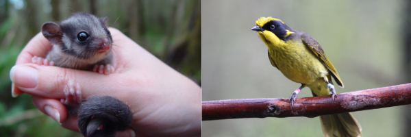
The conservation area is well known for containing the last remaining wild population of the critically endangered Helmeted Honeyeater which was chosen as Victoria’s bird emblem in 1971. The area also supports the only lowland population of the critically endangered Leadbeater’s Possum, which is Victoria’s faunal emblem.
The conservation area will contribute to the recovery of these two critically endangered species by creating links of habitat (streams and creeks) between large blocks of public land to enable species to move throughout the landscape.
Two endangered Ecological Vegetation Classes (EVCs) are sited on public land in the Conservation Area: Cool Temperate Rainforest and Swampy Riparian Complex. The Yellingbo Nature Conservation Area supports the extremely rare and threatened Sedge-rich Eucalyptus camphora Swamp vegetation community.
Riparian management licences
To protect waterways and streamside land, stock will no longer have direct access to waterways. To achieve this, grazing licences are being phased out. Adjacent landowners who previously held a grazing licence will have the option of transferring to a riparian management licence, with the primary purpose being conservation.
Livestock must be contained within the livestock owner’s property and be excluded from the Crown land and waterway. A stock exclusion fence is the most effective way to achieve this. The cost of installing a fence is the landowner’s responsibility. Financial support for fencing, weed management and revegetation, is available for eligible adjacent landholders through Melbourne Water’s Liveable Communities, Liveable Waterways Program.
More information can be found on DEECA's water frontage licensing or by contacting the DEECA project team to discuss applying for a riparian management licence.
E-Newsletter
Stay up to date on what’s been happening within the conservation area by signing up for the Liwik Barring LCA E-Newsletter.
E-Newsletter library
FAQs
Recreation opportunities are provided within the Conservation Area where consistent with natural values. There are some areas within the Conservation Area where additional access and recreation opportunities will be provided, and other areas where access and use will be limited due to high conservation values.
Community access to the Conservation Area is supported and encouraged, where consistent with natural values, through the provision of appropriate assets and infrastructure.
Details of specific uses by location are included in the 10-year Plan.
Funding of $10.06 million over 4 years was included in the 2020-21 State Budget, to support the implementation of the 10-year Plan.
The funding will deliver:
- revegetation and weed management
- Crown land surveys
- infrastructure, including gates, fences, signs, and tracks at high visitation sites
- the Yellingbo Landscape Conservation Area component of Melbourne Water’s Stream Frontage Management Program, and
- the continuation of Parks Victoria’s deer control program.
This recent funding builds upon $3.2 million provided as part of the 2014-15 budget for the initial establishment of the conservation area.
The Yellingbo Conservation Area Bushfire Risk Plan was released August 2018. The plan incorporates advice from leading independent bushfire experts and informs a risk-based approach to revegetation and reserve planning that will not increase bushfire risk to the local and broader communities.
The plan includes a series of actions to ensure there is no material increase in bushfire risk, including limiting the extent of revegetation on public land near dwellings, with a minimum setback distance of 100 metres.
The plan also includes a restricted revegetation area near the townships of Yarra Junction, Launching Place, Don Valley, Millgrove and Wesburn, where revegetation on public land is restricted to 10 metres either side of waterways. This measure will provide greater surety to local landholders that bushfire risk and environmental values will be managed effectively.
Community consultation occurred throughout the Upper Yarra Valley and Dandenong Ranges through 2017 and culminated in a survey regarding key themes for the proposed Conservation Area, to assist drafting a 10 Year Plan.
From 13 August to 7 October 2018, we asked for community feedback on the Yellingbo Conservation Area Draft 10 Year Plan. This involved extensive community engagement including a series of workshops and meetings with local communities, pop-up sessions and input via an online survey.
In 2019 a working group comprising representatives of DEECA, Parks Victoria and Melbourne Water carefully reviewed all submissions. While the working group considered all feedback made by the community, any changes made to the plan needed to be practical and actionable and consistent with the government accepted Victorian Environmental Assessment Council (VEAC) recommendations and existing legislation on uses within parks and reserves in Victoria.
A Response to Submissions report has also been produced, to outline how feedback was reviewed and an explanation on why it was or was not incorporated into the final plan.
Further information is available below:
Bushfire Risk Management Plan FAQs
Alternatively, for more information, please email liwik.barringlca@deeca.vic.gov.au or call 136 186.
Useful links
- DEECA Water frontage licensing
- Burndap Birrarung burndap umarkoo, Yarra Strategic Plan
- Environmental Volunteering and Grants
- Melbourne Water - Liveable Communities Liveable Waterways Program
- Parks Victoria - Haining Farm
- Planned Burns Victoria
- Victorian Environmental Assessment Council
- Victorian threatened species
- Wurundjeri Woi Wurrung Cultural Heritage Aboriginal Corporation
- Zoos Victoria – Local Threatened Species
Contact us
Have a question or would like to learn more about the project? We would love to hear from you! Send through an email enquiry or give us a call.
Phone: 136 186
Page last updated: 31/07/25